- Remove Culture filter Culture
- Remove Urban environments filter Urban environments
- Remove Conservation area filter Conservation area
- Remove Lighthouses filter Lighthouses

Bryggen
In the 1300s Bergen was a trading centre of European dimension. The town is thought to have had around 7000 inhabitants and was the largest and most important in the country. In a European context it was an average size town. At this time the most tightly built town area was still mostly east of Vågen from Holmen in the north to Vågsbotn in the south. Already in medieval times, latest in the 1340s, this area was called Bryggen.


Sandviken
Close to the tunnel opening at Amalie Skrams vei in Ssandviken, there is a cultural monument of European dimensions; a rope making works that produced rope and fishing tackle for West and North Norway.

Strandsiden
During the 1300s Strandsiden changed from a rural area with a monastery to a pulsating trading centre with boathouses, storehouses and embankment.

Vågsbunnen
Vågsbotn was the name of the innermost part of the eastern part of town from Auta-almenning (today’s Vetrlidsalmenning), skirting the bottom of Vågen to Allehelgenskirken (All Saints’ Church) (at the present Allehelgensgate). In early medieval times Vågen reached almost all the way to Olavskirken (the Cathedral). It was a relatively wide bay inside the premonitory where Korskirken was built. The area was therefore much shorter than what is known as Vågsbunnen today.

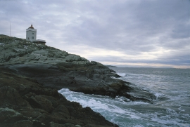
Hellisøy
Hellisøy lighthouse was lit for the first time in 1855. The characteristic red cast-iron tower with two white belts is 33m high and a light height of 46m above high tide.

Stølsheimen
The large mountain area between Modalen, the Voss communities and Sogn is one of the finest mountain pasture areas in West Norway. In older times this area was called Steinslandsheimen, in our times it has acquired the name Stølsheimen. Power development and protection interests have been opposed here. The core area of Stølsheimen has now been protected as a landscape protection area, while some of the oldest mountain farms have been flooded. A register in the 1970s comprised almost 40 mountain farm settlements in the central area of Stølsheimen, belonging to Modalen, Høyanger and Vik municipalities.

Hystad- burial mounds
The biggest collection of prehistoric burial relics in Stord is to be found in Hystadmarka. There are still 16 burial mounds and two stone rings visible here; finds that span from the Bronze Age to the Viking Age in time.
Ryvarden
In the Islandic Landnåmabok there is a story that the explorer Floke Vilgjerdsson built a cairn “where meetest Hordaland and Rogaland” and the cairn was named Flokavarði. Tormod Torfæus wrote in Historia Norvegica (1711) that this name was still in use, but that the farmers used “Ryvarden” for the same place.

Berge
Down by the fjord on the farm Berge in Tørvikbygd, is Stekkavika – a sheltered eastward facing harbour, protected against the fjord by headlands and rocks, even manifest in the name. Here is also a comprehensive milieu of coastal industry, with boathouses and sea-sheds that belong to the farms Berge, Heradstveit and Halleråker. Belonging to the farm Berge there is also a mill-house, circular saw, workshop for sloop building, and – a little further up into the woods – the old water-powered sash-saw.

