- Remove Cultural landscapes filter Cultural landscapes
- Remove Samnanger filter Samnanger
- Remove Voss, frå 2020 del av nye Voss herad. filter Voss, frå 2020 del av nye Voss herad.
- Remove Archaeological findings filter Archaeological findings
- Remove Chieftains and royal lines filter Chieftains and royal lines
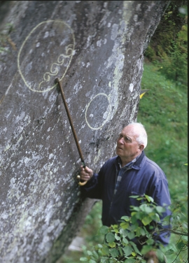
- Remove Rock carvings filter Rock carvings
- Remove Vaksdal filter Vaksdal
- Remove Meland, frå 2020 del av nye Alver kommune. filter Meland, frå 2020 del av nye Alver kommune.


Håøy
Håøy lies centrally in one of the main shipping lanes going into Bergen --- with Håyøsund on the south side facing Meland, and Hagelsundet facing Lindåslandet. Names like Nordfarskista and Nordfarsskorane explain things. The strategic position was important in Viking times and it has been important in our days too. The beacon on Håøy can have been built in the establishment of the coastal administration in Håkon the Good’s time, about 950 AD. The defence structure of which we say remains on Håøy Summit held a critical position during Norwegian neutrality during the First World War. The defence structure was taken down in 1957.

Husebø
When the Corncrake returned to Nordhordland, it came as no surprise that Husebø was the place it chose. Here, remnants of the old cultural landscape are still in good condition. And the Corncrake is not alone in appreciating this.

Dale farm
The Dale farm lies well situated on the gravel by the river, below the mountain Beitelen. But a few stone throws further north, on the wide expanse behind the houses, there has been an older farmstead. Here there have been found a number of cooking hollows, pole holes, an old road and traces of something believed to have been a palisade. Finds from this oldest farmstead may be dated to the time of the migrations, 400-600 years A.D.


Skipshelleren
For vel 7000 år sidan var Straume ein av dei beste – om ikkje den beste – veideplassen i Hordaland. Steinalderfolket som busette seg ved Skipshelleren, skjøna truleg ikkje kor heldige dei var. Mellom dei opptil 2 meter tjukke dyngjene med stein og bein som arkeologar grov fram i 1931–32, fann dei reiskapar og avfall frå fangst og matstell. Frå dette materialet har arkeologane stava seg fram til livet ved straumen.


Byrkjehaugen
On the farm Bø, close to the highway between Bulken and Voss lies Byrkjehaugen, one of the largest burial mounds in West Norway. Originally it was around 50m across and 5m high, but following the excavation in 1908 and chipping off by both railway and road construction, the cross-section has shrunk to 37m and the height to 4m. All the same, it is an impressive burial monument for the passing traveller to see.