- Remove Cultural landscapes filter Cultural landscapes
- Remove Samnanger filter Samnanger
- Remove Voss, frå 2020 del av nye Voss herad. filter Voss, frå 2020 del av nye Voss herad.
- Remove Archaeological findings filter Archaeological findings
- Remove Quarries filter Quarries
- Remove Masfjorden filter Masfjorden
- Remove Late glacial filter Late glacial


Matrehola
On a large gravel terrace in Matredalen (the Matre valley), a couple of kilometres from the coastal settlement Matre, lies Storseterhilleren, at the end of a large stone block that came rushing down from the mountain. The Matre river runs just over 100 metres to the east of the cave.


Bordalsgjelet
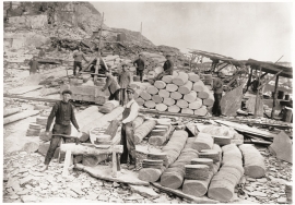
Deep down between the stone polished phyllite bedrock in Bordalsgjelet canyon, there is a cascading river. In close cooperation with hard polishing stones, the water has carved into the bedrock for thousands of years - and is still doing so today.


Byrkjehaugen
On the farm Bø, close to the highway between Bulken and Voss lies Byrkjehaugen, one of the largest burial mounds in West Norway. Originally it was around 50m across and 5m high, but following the excavation in 1908 and chipping off by both railway and road construction, the cross-section has shrunk to 37m and the height to 4m. All the same, it is an impressive burial monument for the passing traveller to see.

Nordheim
"And here these endless kingdoms and these toils for a rich working life far and wide have lain and slept for a hundred thousand years! Right up until the Voss Railway came in 1883 and woke them, like the prince in the fairytale who awakened the Sleeping Beauty."

Ulvund
One of the oldest farms in Myrkdalen, Ulvund, is recognized as one of 14 areas in Hordaland having an especially valuable cultural landscape. The dirt road runs along a steep slope down toward Lake Myrkdalsvatnet. The flattest field, which today is harvested for silage, used to be an old grain field, while the slopes were old hayfields.

