- Remove Boats and seafaring filter Boats and seafaring
- Remove Late glacial filter Late glacial
- Remove Sedimentary rocks filter Sedimentary rocks
- Remove Kvinnherad filter Kvinnherad
- Remove Fjell, frå 2020 del av nye Øygarden kommune filter Fjell, frå 2020 del av nye Øygarden kommune
- Remove Faults filter Faults
- Remove Granvin, frå 2020 del av nye Voss herad filter Granvin, frå 2020 del av nye Voss herad

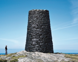
Bondhusdalen
The Bondhus area in Maruanger has been a magnet for tourists ever since the stream of tourists to Norway's west coast began in the middle of the 1800s. The magnificent landscape with the "ice trail" up to Bondhusvatnet Lake, the ice falls from Bondhusbreen glacier and Keisarstigen trail up to Folgefonna are still popular tourist attractions.

Halsnøy
Hadde ikkje Hardangerfjordbreen mot slutten av istida rykt fram over fjordbotnen, ville Halsnøy ikkje eksistert som éi øy, men som mange småøyar. Breen skuva framfor seg så mykje leire frå havbotnen at Brattåsen, Toftåsen, Landåsen og Svartaberg vart samla i eitt landområde.


Skorpo
Skorpo - Polished by glaciers and meltwater


Ølve
Ølve has a special soil type. Here one finds an extra hard clay soil. This is especially noticed by those who work with excavating for building foundations and the like. Often it is necessary to use especially big digging machines and sometimes even dynamite in order to break up the compact masses. The reason for this is the growth of the glaciers toward the end of the Ice Age: The clay, that was first deposited in front of the glacier, came under great pressure when the glacier later grew and slid out over the clay.

Skjervet- river theft
At the end of the last ice age the ice flowed out of Hardanger fjord in such a fury that it forced the meltwater from Voss to run back uphill toward Granvin. The glacier from Raundalen down the windy valley along the Vosso to Bolstadøyri went too slow to make the turn.

Haganes
The gneiss landscape west and north of Bergen viewed in profile can remind us of a saw blade of the kind that has long, slanted sides that get broken off shorter transverse sides. It has taken several hundred million years to file this saw blade, an enduring interplay between various geological processes.