- Remove Smallholdings filter Smallholdings
- Remove Civil servant dwellings and manors filter Civil servant dwellings and manors
- Remove Faults filter Faults
- Remove Kvam filter Kvam
- Remove Fitjar filter Fitjar

Fitjarøyane
If we study the group of islands south of Selbjørns Fjord from the air or on a sea map, we will notice that many of the islands are elongated and lie systematically in rows. The islands are divided by long sounds, for example Trollosen, Nuleia and Hjelmosen, which are oriented in a south-southeast to north-northwesterly direction.

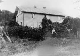
Tangarås
From his loft window on the doctor’s farm at Tangarås the young Hans Ernst Kinck had a view of the fjord and the Mauranger mountains. The fjord settlements in West Norway made a strong impression on the young boy when his family moved from Setesdal, from “the stifling mystique of the ballad”, to Strandebarm in 1876. The new district doctor bought the old captain’s farm at Tangarås, which had for some time been a military head farm after Håbrekke further into the settlement.

Vikøy
Through Adolph Tidemand’s detailed close-ups of smokehouses in Kvam, the vicarage in Vikøy, where he lived during his painting trips through Hardanger, has obtained a central position in the Norwegian national romanticism.

