- Remove Smallholdings filter Smallholdings
- Remove Civil servant dwellings and manors filter Civil servant dwellings and manors
- Remove Faults filter Faults
- Remove Sunnhordland filter Sunnhordland


Fitjarøyane
If we study the group of islands south of Selbjørns Fjord from the air or on a sea map, we will notice that many of the islands are elongated and lie systematically in rows. The islands are divided by long sounds, for example Trollosen, Nuleia and Hjelmosen, which are oriented in a south-southeast to north-northwesterly direction.


Sørhuglo
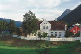
The tax collector’s farm at Sørhuglo is one of the many farms for state employees in Hordaland. According to history, “Futastovo” was built by the tax collector Gram in the second half of the 17th century. In 1943 the building was moved to Sunnhordland Folk Museum.

Einstapevoll- the farm
Einstapevoll (from einstape: “bregne” (fern)) lies on the west side of the Tittelsnes peninsula. Up to 1831 the farm was a vicarage belonging to Stord parish. The priests had leasing rights. Land rent and other fees from the farm was part of their salaries.

Krokavatnet
On Sunday the 29th of January, 1989, at 17:38 o'clock, Etna shook. The earthquake, with its epicentre ca. 9 kilometres south of Etne centre, had a strength of 4.2 on the Richters scale. This could be felt over large parts of West Land, especially in the areas around Åkra, Etne, Hardanger Fjord and Sauda Fjord. The earthquake was the largest that has ever been measured in Hordaland.

