- Remove Smallholdings filter Smallholdings
- Remove Igneous rocks filter Igneous rocks
- Remove Defense filter Defense
- Remove Deciduous forests filter Deciduous forests
- Remove Nordhordland filter Nordhordland

Vinappen
Vinappen lies on a low hill to the very west on the island. Here you have an amazing panorama of the sea. Originally the area was grazing land for cattle, but this changed when the Germans occupied the island. Just before WWII there was a small bearing station, used by the Norwegian Coast Artillery in connection with exercises at sea.

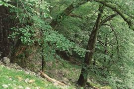
Vollom
On Vollom, northwest of Seim, we find the only natural beech forest in Western Norway, which is also the most northerly of its type in the world. Beech grows also many other places in the county, but these trees are totally lacking in history compared with those of Vollomskogen Forest.


Håøy
Håøy lies centrally in one of the main shipping lanes going into Bergen --- with Håyøsund on the south side facing Meland, and Hagelsundet facing Lindåslandet. Names like Nordfarskista and Nordfarsskorane explain things. The strategic position was important in Viking times and it has been important in our days too. The beacon on Håøy can have been built in the establishment of the coastal administration in Håkon the Good’s time, about 950 AD. The defence structure of which we say remains on Håøy Summit held a critical position during Norwegian neutrality during the First World War. The defence structure was taken down in 1957.

Manger
Mangerite is a rock type that was first made famous in a treatise by the Bergen geologist Carl Fredrik Kolderup in 1903. The rock type got its name from the place where it was found, and has made the Mangerud name well known around the world, at least among geologists.


