- Remove Smallholdings filter Smallholdings
- Remove Basement rocks filter Basement rocks
- Remove Hardanger og Voss filter Hardanger og Voss
- Remove Road constructions filter Road constructions
- Remove Stone age filter Stone age

Agastølen
Whoever wanders the mountain plateau will form time to time hit upon old mountain summer farms, with solid old stone sheds, half sunk into the ground; a building tradition that has roots into prehistoric times. When we have been satiated with untouched Nature, it is somewhat comforting to come upon the old mountain chalets - they represent a type of human encroachment that we not only accept, but appreciate. They arouse a feeling of recognition and are a distinct witness to how people in the rural communities have made use of even the most remote resources.

Halne
At Halnefjorden, a few hundred metres east of Halne mountain lodge, lie the remains of two stone sheds – Halnelægeret. Some generations ago the cattle drovers stopped here in the summer; they were the cowboys of their time. But Halnelægeret already had a long history before the cattle drovers came.


Lussand- geology
Hardangerfjorden kløyver Hordaland i to. Den etter måten rettlinja fjorden skjer seg liksom på skeive inn i landet. Ikkje som Sognefjorden og Nordfjord – dei krokar og buktar seg innover meir eller mindre vinkelrett på kysten. Hardangerfjordens utforming har røter 400 millionar år tilbake i tida, då den veike sona i fjellet, der isen seinare tok grådig for seg, vart danna. Denne sona stig på land ved Lussand.

Lussand-roadwork
The road along the north side of the Hardanger fjord - between Øystese and Eide in Granvin – was literally built “by hand”. The construction work started in February 1933, and on 9 October 1937 Crown Price Olav opened the stretch of road between Øystese and Ålvik at Fyksesund bridge.

Skjervet- road construction
The road between Eide in Granvin and Voss is one of the oldest roads mentioned in the Middle Ages. In a diploma from 1343 from Voss regarding distribution of road works, we also find mention of the road to Angr (the Granvin fjord).

Rallarvegen
They rest there, all as one, the silent witnesses of Western Norway's saga of creation: Precambrian basement, phyllite and thrust sheet. In the end came the glaciers and sculptured the vast landscape. Along the ground or on the horizon, from bicycle or on foot - the landscape tells its story - and it tells it clearer on Rallarvegen than many other places.

Tokagjelet
There is a sharp transition between the wide valley at Kvamskogen and the narrow Tokagjelet. The transition is no less dramatic when we come out of the crooked tunnels far down in the canyon, and the open Steinsdalen valley spreads out before us. The canyon both separates and joins together different epochs in western Norway's history.
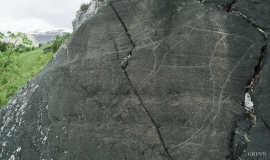
Vangdal
At Salthamaren in Vangdalsberget it is thought that salt was burned some time in history, and deep layers of coal in the ground show that fire has been made up here several times. But they were hardly salt-burners, the first people who stopped here. Some of them carved figures into the rock. On top of the rocky outcrop, furthest out on the cliff, a group of Stone Age hunters carved animal figures. More than 1,500 years later Bronze Age farmers drew ship figures at the foot of the rock. Both these works of art - some of the oldest in Hordaland – are still visible, carved in the rock at Salthamaren.

