- Remove Music filter Music
- Remove Hydro power filter Hydro power
- Remove Midthordland filter Midthordland
- Remove Faults filter Faults


Haganes
The gneiss landscape west and north of Bergen viewed in profile can remind us of a saw blade of the kind that has long, slanted sides that get broken off shorter transverse sides. It has taken several hundred million years to file this saw blade, an enduring interplay between various geological processes.

Vatlestraumen
There are coal bits hidden in the sand under Vatlestraumen. These remains from a geological layer from the Jurassic Period were discovered when the undersea Bjorøy Tunnel was built in 1994. Oil- and gas reservoirs in the Troll Field in the sea west of Hordaland are from the same time. It is, nonetheless, quite surprising to find bedrock from dinosaur time inside of the outer islands of western Norway. On the Scandinavian mainland north of Denmark, there are only a very few places where one f inds rock from this time in earth history.

Frøland
Much rain, a steep drop and nearness to Bergen meant that the power-making potential of the Samnanger water system was exploited early. Samnanger was thus one of the first power-producing municipalities in western Norway. With its subsequent expansion and new power stations, about 400 gigawatts of electricity per hour were produced on average each year. This is enough to meet the energy needs of 25,000 households.


Toftestallen
The large coastal waves that crash down on the islands west in the sea gather their energy from storms and winds all the way out in the North Atlantic Ocean. The most common place of origin is nonetheless the North Sea. When these waves break over the skerries and islets along the shore, or on the rocky outermost islands, their energy is released. This takes the form of turbulence in the water and sea spray up on land. Can the enormous energy contained in the waves be exploited?
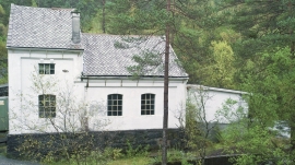
Gåssand
The 28th November 1914 was a day to remember for the Os inhabitants. This was the day they could turn the switch on the wall and have electric light in their houses. It was like opening the door on the future when the power station at Gåssand was put into operation.
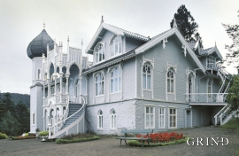
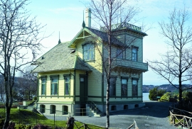
Lysøen
Lysøen, this fairytale castle with its Russian-inspired onion dome on the corner turret, stands as a reminder of the diversity of the period called Historicism and a monument to a versatile artist; a key figure in the Norwegian National Romanticism.

