- Remove Basement rocks filter Basement rocks
- Remove Midthordland filter Midthordland
- Remove Archaeological findings filter Archaeological findings
- Remove Hydro power filter Hydro power
- Remove Maritime environments filter Maritime environments
- Remove Lakes, rivers and river networks filter Lakes, rivers and river networks
- Remove Large landforms filter Large landforms


Nordåsvatnet
The Post-war Era came to Fana with its population growth and modern sanitary equipment. This had nearly catastrophic consequences for Nordåsvatnet as a recreational area. After the runoff water got re-directed to deeper water, and later also to the fjord outside, Lake Nordås won back both its swimming guests and its sports fishermen.


Åsane
Most associate Åsane with ridges, naturally enough (the Norwegian word for "ridge" is "Ås"). A lesser noticed trait in the landscape are the unusual flat areas that lie between the ridges. The Dalselva River, which was channeled at the end of the 1950s, runs down only 2.5 metres from Lake Langavatnet by Vågsbotn to Flatevad, where it goes over into rapids by Fossekleiva. The layers of gneiss stand nearly vertically, and the mountain surface is so even that one might think it had been planed with a planer.

Eidsbøen
Where the school and the sports facility lie at Eidsbøen there was previously a bog surrounded by small hillocks. More than 1000 years ago this was a holy place, where the dead were buried.

Holmefjord
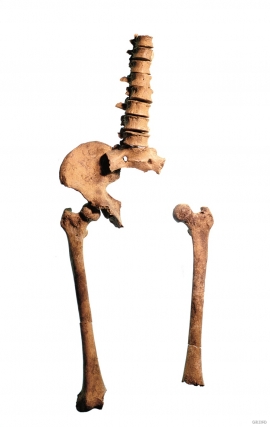
Even though we know of several hundred burial places from the Stone Age in Hordaland, we do not often hit on the Stone Age Man himself. But there are a few.

Skogseidvatnet
Lake Skogseidvatnet is the most famous fishing lake in Hordaland, with good stocks of both char and trout. There is fishing here throughout the year: with a net in the autumn, through the ice in winter, and with a fishing rod in the summer.


