- Remove Small landforms filter Small landforms
- Remove Cultural landscapes filter Cultural landscapes
- Remove Conservation area filter Conservation area
- Remove Lindås, frå 2020 del av nye Alver kommune. filter Lindås, frå 2020 del av nye Alver kommune.
- Remove Voss, frå 2020 del av nye Voss herad. filter Voss, frå 2020 del av nye Voss herad.
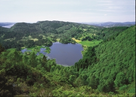
Fossevatna
Fossevatna, some few kilometres north of Alversund, is one of the finest wetland areas in Lindås. Especially the birdlife has made this place well known. Throughout the year, one can make exciting bird discoveries. But, if you want to hear the flight games skal høre med fagredaktør Stein Byrkjeland of the Snipe, you should come here on a spring or summer evening.

Lurekalven
Lurekalven is an unpopulated island of heather moor which is a part of the wilderness belonging to the five farms on Ytre Lygra. Between the two islands there is only a small sound. As late as the 1920s, milking cows were rowed over the sound from Lygra in summer – a form of farming that was adapted to the coastal landscape.

Lygra
The heath landscape on outer Lygra, Utluro and Lurekalven will in future become part of a landscape protection area, to be maintained through traditional activities with year-round outdoor sheep, grazing and burning. The West Norwegian heath country belongs to a large North Atlantic coastal landscape stretching from the Bay of Biscay to the Lofoten islands.


Vollom
On Vollom, northwest of Seim, we find the only natural beech forest in Western Norway, which is also the most northerly of its type in the world. Beech grows also many other places in the county, but these trees are totally lacking in history compared with those of Vollomskogen Forest.

Bordalsgjelet
Deep down between the stone polished phyllite bedrock in Bordalsgjelet canyon, there is a cascading river. In close cooperation with hard polishing stones, the water has carved into the bedrock for thousands of years - and is still doing so today.


Lønaøyane
The Strandaelvi river is forever protected from the development of hydropower. The Lønaøyane islands – which comprise the delta furthest north in Lake Lønavatnet - are a part of this water system. In 1995 the level of protection for the Lønaøyne islands was strengthened to that of a nature preserve because of the rich birdlife in this wetland.

Rekvesøyane
The sediment that was deposited from the river Dyrvo has created the fan-shaped delta Rekvesøyane. The bit of land farthest out toward the water gets periodically flooded, especially during snow melt and after periods of much rain.

Ulvund
One of the oldest farms in Myrkdalen, Ulvund, is recognized as one of 14 areas in Hordaland having an especially valuable cultural landscape. The dirt road runs along a steep slope down toward Lake Myrkdalsvatnet. The flattest field, which today is harvested for silage, used to be an old grain field, while the slopes were old hayfields.

