- Remove Small landforms filter Small landforms
- Remove Maritime environments filter Maritime environments
- Remove Seabirds filter Seabirds
- Remove Monastery filter Monastery
- Remove Fitjar filter Fitjar
- Remove Avalanches and rock falls filter Avalanches and rock falls
- Remove Etne filter Etne
- Remove Igneous rocks filter Igneous rocks
- Remove Stord filter Stord
- Remove Farm sites filter Farm sites

Fitjarøyane
If we study the group of islands south of Selbjørns Fjord from the air or on a sea map, we will notice that many of the islands are elongated and lie systematically in rows. The islands are divided by long sounds, for example Trollosen, Nuleia and Hjelmosen, which are oriented in a south-southeast to north-northwesterly direction.


Årskog
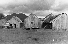
Årskog farm is situated in a typical coastal landscape in a gentle terrain that slopes down from the outlying heaths down towards the fjord. The farm steading exists as it was in the 1800s. In 1980 the two brothers, Lars and Olai Årskog donated the farm with all its contents of tools and interior decoration, for museum purposes.

Kattnakken–Stovegolvet
The highest mountainous area on Stord, including Kattnakken, Midtfjellet and Stovegolvet, has more in common with the mountainous terrain on the mainland than in the low coastal landscape of Sunnhordland. The volcanic bedrock together with the erosive powers of nature has resulted in a unique plateau landscape.

Ådlandsstova
The Ådland house is one of the biggest medieval houses still existing in West Norway. It is constructed from unusually large, hard fir wood, beautifully oval-cut. One story links the cottage to the Gildeskålbakken at Orninggård (Lower Ådland); thus indicating that the cottage has been the medieval banqueting hall. The building has been dated back to the 13-1400s by carbon dating.

Mosnes
The permanently-protected Mosneselva River, with its meltwater from Folgefonna, runs out into Åkra Fjord by the roadless and uninhabited Mosnes. Those who once lived here were forced to surrender to the ravages of Nature. In the autumn of 1962 there was a flood so great that the people were driven from their farms.
Sæbøtunet
When you come into the well-tended farm steading at Sæbø just above Etne centre, you get the impression of a Sunnhordland farm from well before the time of the tractor; from the time of the horse and the scythe. The hamlet at Sæbø, one of the farms neighbouring to Gjerde, was taken over by Sunnhordland Folk Museum in 1938.

