- Remove Small landforms filter Small landforms
- Remove Maritime environments filter Maritime environments
- Remove Seabirds filter Seabirds
- Remove Monastery filter Monastery
- Remove Fitjar filter Fitjar
- Remove Ullensvang, frå 2020 del av nye Ullensvang kommune. filter Ullensvang, frå 2020 del av nye Ullensvang kommune.
- Remove Middle age filter Middle age
- Remove Large landforms filter Large landforms
- Remove Stord filter Stord


Fitjarøyane
If we study the group of islands south of Selbjørns Fjord from the air or on a sea map, we will notice that many of the islands are elongated and lie systematically in rows. The islands are divided by long sounds, for example Trollosen, Nuleia and Hjelmosen, which are oriented in a south-southeast to north-northwesterly direction.


Huglo
The majority of Huglo is bare rock. A bit of dwarf pine forest is the only vegetation able to put down roots. Along the west- and east sides, to the contrary, the landscape is unusually green and lush. The reason lies both in the bedrock and in the ice that covered the area 12 000 years ago.

Kattnakken–Stovegolvet
The highest mountainous area on Stord, including Kattnakken, Midtfjellet and Stovegolvet, has more in common with the mountainous terrain on the mainland than in the low coastal landscape of Sunnhordland. The volcanic bedrock together with the erosive powers of nature has resulted in a unique plateau landscape.

Ådlandsstova
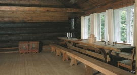
The Ådland house is one of the biggest medieval houses still existing in West Norway. It is constructed from unusually large, hard fir wood, beautifully oval-cut. One story links the cottage to the Gildeskålbakken at Orninggård (Lower Ådland); thus indicating that the cottage has been the medieval banqueting hall. The building has been dated back to the 13-1400s by carbon dating.

Aga
The grand farm Aga on the west side of Sørfjorden, came under protection in 1937, when the agricultural reform threatened to disperse the old clustered settlement. “Lagmannsstova”, named after the “lagmann” (law speaker) Sigurd Brynjulfsson, was already protected in 1924; one of the authentic profane wooden buildings from the Middle Ages still standing. All the same it is the farmyard itself that is the key cultural monument.
Jåstad
The farm Jåstad, situated a few kilometres north of Agatunet, must have been a grand farm in medieval times. Torolf on Jåstad is mentioned as arbitration moderator in 1293, and in the vaulted corridor at Lyse Kloster Sigurd, farmer at Jåstad, and his wife Sigrid – the king’s kinswoman - are buried.

Kinsarvik
Kinsarvik has probably been a centre for the inner Hardanger districts back in prehistory. History tells us that in medieval times there was a marketing place, a “kaupang”, here; a connecting point in the communications between east and west. There were supposedly around 300 residents here but the place was likely wiped out in a great fire.

