- Remove Small landforms filter Small landforms
- Remove Maritime environments filter Maritime environments
- Remove Seabirds filter Seabirds
- Remove Monastery filter Monastery
- Remove Fitjar filter Fitjar
- Remove Ullensvang, frå 2020 del av nye Ullensvang kommune. filter Ullensvang, frå 2020 del av nye Ullensvang kommune.
- Remove Etne filter Etne
- Remove Rock carvings filter Rock carvings
- Remove Large landforms filter Large landforms
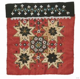
- Remove Farm sites filter Farm sites

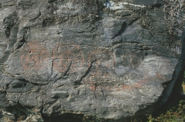
Helgaberget
Helgaberget – the holy hill – is a little rocky crag which thrusts itself a few metres above the terraced surface of Støle. The surface of the rock is strewn with figures inscribed in the rock and it was, as far as one can judge, a cult centre in the Bronze Ages. The name could indicate that the tradition of holiness can have lasted for almost 3,000 years.


Fitjarøyane
If we study the group of islands south of Selbjørns Fjord from the air or on a sea map, we will notice that many of the islands are elongated and lie systematically in rows. The islands are divided by long sounds, for example Trollosen, Nuleia and Hjelmosen, which are oriented in a south-southeast to north-northwesterly direction.


Årskog
Årskog farm is situated in a typical coastal landscape in a gentle terrain that slopes down from the outlying heaths down towards the fjord. The farm steading exists as it was in the 1800s. In 1980 the two brothers, Lars and Olai Årskog donated the farm with all its contents of tools and interior decoration, for museum purposes.

Aga
The grand farm Aga on the west side of Sørfjorden, came under protection in 1937, when the agricultural reform threatened to disperse the old clustered settlement. “Lagmannsstova”, named after the “lagmann” (law speaker) Sigurd Brynjulfsson, was already protected in 1924; one of the authentic profane wooden buildings from the Middle Ages still standing. All the same it is the farmyard itself that is the key cultural monument.