- Remove Small landforms filter Small landforms
- Remove Maritime environments filter Maritime environments
- Remove Seabirds filter Seabirds
- Remove Monastery filter Monastery
- Remove Fitjar filter Fitjar
- Remove Ullensvang, frå 2020 del av nye Ullensvang kommune. filter Ullensvang, frå 2020 del av nye Ullensvang kommune.
- Remove Austevoll filter Austevoll
- Remove Large landforms filter Large landforms


Fitjarøyane
If we study the group of islands south of Selbjørns Fjord from the air or on a sea map, we will notice that many of the islands are elongated and lie systematically in rows. The islands are divided by long sounds, for example Trollosen, Nuleia and Hjelmosen, which are oriented in a south-southeast to north-northwesterly direction.


Ullensvang church
Ullensvang church, situated beside the vicarage, in idyllic surroundings on the headland just inside Lofthus municipality, is mentioned for the first time in written sources in 1309. At that time the present Gothic stone church must have been new. Judging by the style in the western portal and the eastern chancel windows, the church must have been built around 1300 or just before, probably by builders from Bergen influenced by the English Gothic style.

Hårteigen
Hårteigen, «the grey signpost», as the name suggests, is a landmark for mountain hikers on the western plateau. The piece of mountain is also a monument for the mighty rock layers that once covered the entire plateau.
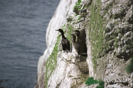
Møkster- seabirds
Fish and guests smell after three days, it is said. The cormorants do not need this long. If you follow your nose, the cormorant is not difficult to find.

