- Remove Modalen filter Modalen
- Remove Maritime environments filter Maritime environments
- Remove Sund, frå 2020 del av nye Øygarden kommune filter Sund, frå 2020 del av nye Øygarden kommune
- Remove Fisheries filter Fisheries
- Remove Nordhordland filter Nordhordland
- Remove Radøy, frå 2020 del av nye Alver kommune. filter Radøy, frå 2020 del av nye Alver kommune.
- Remove Austrheim filter Austrheim
- Remove Wetland filter Wetland

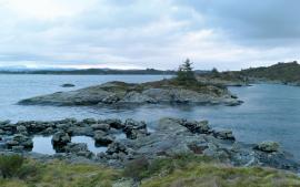
Krossøy
Furthest north in the island community Rongevær, at the entrance to Fensfjorden, lies Krossøy. Belonging to the farm are the islands of Krossøy, Husøy, Kårøy, Lyngkjerringa, Søre Kjerringa, Rotøy and Kuhovet. All of them have been inhabited. On Krossøy itself today there are four holdings. The marine use environment here is one of the best preserved along the West Norwegian coast.

Leirvågen
A marsh is a grassy meadow that is strongly influenced by salt from the sea. This type of nature is abundant in Denmark, among other places. The flatlands along the river that run out by Leirvågen, are the municipalities' largest marsh. At spring tide, these flatlands are flooded underwater for several hundred metres in over land.


Otterstad
Tthe Otterstad farms lie in the innermost part of Mofjorden, on the northwest side of the river. The row of stave-built boatsheds that belong to the farm were probably constructed a little after the middle of the 1800s. Both here and on the Mo side, the boatsheds were important storage places at the seashore; wood and other farm products intended for the town; corn and merchandise in return.

Fosnstraumen
At the southern end of the bridge between Radøy and Fosnøy archaeologists found an unusual Stone Age settlement. There was a thick “cultural layer” here with the remains of the waste dumps of a hunting people. The place was called Kotedalen. Here they came, one group after the other, and settled for some weeks, some months, or maybe years before they went on, leaving the settlement deserted. Time after time it happened. At least 16 settlement phases have been identified, stretching over 5,500 years.

Toska
The peat bogs on Toska have been mined for peat since 1946, when the island got electricity. In this treeless coastal landscape, peat was the most important source of energy, and this took quite a toll on the bogs.

Purkebolsvatnet
Lake Purkebolsvatnet is perhaps western Norway's largest sleeping city - for birds. They come in the thousands, usually in later summer and autumn. The barn swallows alone number 10 000 - 12 000 at their most numerous.

Myking
Between Lake Kvalheimsvatnet and Lake Mykingsvatnet, north of Grindheim, we find one of the biggest continuous lowland bogs in Hordaland. It is 500-600 metres across and a whole 2 kilometres long. Locally, the bog is called "Havet" .

