- Remove Modalen filter Modalen
- Remove Settlements, Villages, Towns filter Settlements, Villages, Towns
- Remove Sveio filter Sveio
- Remove Tysnes filter Tysnes

Nottveit
In one of the frame-built haysheds at Nottveit, at holding No. 3, we discover that several of the staves have a medieval look, with large dimensions and carefully rounded edges. According to tradition, it was the farms Nottveit and Mostraumen that supplied the timber for the stave church at Mo, and it is not unlikely that these farms received the old timber in return when the new church was erected there in 1593.

Otterstad
Tthe Otterstad farms lie in the innermost part of Mofjorden, on the northwest side of the river. The row of stave-built boatsheds that belong to the farm were probably constructed a little after the middle of the 1800s. Both here and on the Mo side, the boatsheds were important storage places at the seashore; wood and other farm products intended for the town; corn and merchandise in return.

Einstapevoll- the farm
Einstapevoll (from einstape: “bregne” (fern)) lies on the west side of the Tittelsnes peninsula. Up to 1831 the farm was a vicarage belonging to Stord parish. The priests had leasing rights. Land rent and other fees from the farm was part of their salaries.

Haugsbø
The single unit farm without a road to it, Haugsbø, is situated on the east side of the Tittelsnes peninsula facing Ålfjorden. As far back as the Middle Ages the farm has probably belonged to Stord Parish, up to the 1800s. In 1590 it was thought to be abandoned, but in 1601 Mickel Hougsbøe paid a tithe on the farm.
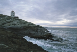
Ryvarden
In the Islandic Landnåmabok there is a story that the explorer Floke Vilgjerdsson built a cairn “where meetest Hordaland and Rogaland” and the cairn was named Flokavarði. Tormod Torfæus wrote in Historia Norvegica (1711) that this name was still in use, but that the farmers used “Ryvarden” for the same place.

Færavåg
The main house at Færavåg was built in 1599. History tells us that a German came to Færavåg and built the house. He divided the land between his two sons. They in turn divided it between their two sons, thus there were four equal holdings on the farm. And it is said that all households lived in the same house. They each stayed in their own corner around the fire in the middle of the floor.

Godøysund
The old hostelry centres were strategically placed with good harbours and anchoring conditions where people travelled. GODØYSUND, or Gøysundet, as it was called, was in the middle of Tysnes Parish, with easy access from the sea, also for the local population. Gøysundet is amongst the oldest hostelries in Sunnhordland.


Klinkholmen
Kubbervik, or Vikjo as it was known colloquially, must have been established as a trading post under the farm of Håland some time around 1600. The reason for this was probably the thriving trade on Scotland. Every year ships from the islands in the west came to buy lumber in Bårsund. Vikjo was the harbour in use, as the place is ideally situated on the route through Bårsund, the sound between Reksteren and Tysnesøy.

Nedrevåge
Vågsbygdo was severely hit by landslides and rock falls in the decades around 1700, in addition, the rivers transported masses of loose sediment, both large stones and gravel. A lot of what slid down from the Vågsliene (slopes at Våg) collected in Neravåge. It was so bad that the damage “never again can be remedied or restored”, it was said in 1670.

