- Remove Modalen filter Modalen
- Remove Settlements, Villages, Towns filter Settlements, Villages, Towns
- Remove Sveio filter Sveio
- Remove Voss, frå 2020 del av nye Voss herad. filter Voss, frå 2020 del av nye Voss herad.

Nottveit
In one of the frame-built haysheds at Nottveit, at holding No. 3, we discover that several of the staves have a medieval look, with large dimensions and carefully rounded edges. According to tradition, it was the farms Nottveit and Mostraumen that supplied the timber for the stave church at Mo, and it is not unlikely that these farms received the old timber in return when the new church was erected there in 1593.

Otterstad
Tthe Otterstad farms lie in the innermost part of Mofjorden, on the northwest side of the river. The row of stave-built boatsheds that belong to the farm were probably constructed a little after the middle of the 1800s. Both here and on the Mo side, the boatsheds were important storage places at the seashore; wood and other farm products intended for the town; corn and merchandise in return.

Einstapevoll- the farm
Einstapevoll (from einstape: “bregne” (fern)) lies on the west side of the Tittelsnes peninsula. Up to 1831 the farm was a vicarage belonging to Stord parish. The priests had leasing rights. Land rent and other fees from the farm was part of their salaries.

Haugsbø
The single unit farm without a road to it, Haugsbø, is situated on the east side of the Tittelsnes peninsula facing Ålfjorden. As far back as the Middle Ages the farm has probably belonged to Stord Parish, up to the 1800s. In 1590 it was thought to be abandoned, but in 1601 Mickel Hougsbøe paid a tithe on the farm.
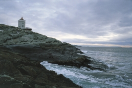
Ryvarden
In the Islandic Landnåmabok there is a story that the explorer Floke Vilgjerdsson built a cairn “where meetest Hordaland and Rogaland” and the cairn was named Flokavarði. Tormod Torfæus wrote in Historia Norvegica (1711) that this name was still in use, but that the farmers used “Ryvarden” for the same place.

Bolstad
The village at Bolstadøyri acquired its structure around the middle of the 1800s, but from the old days there has been a meeting place here; court location and trading post. The guesthouse place stems from the second half of the 17th century, and in the previous century Bolstadøyri was one of the largest rural trading posts in Nordhordland.

Evanger
Evanger (from Old Norse ålvangr, “vang”, “voll” (field) where the horses may graze) is the place where the river from Vangsvatnet, the Voss watercourse, runs out into Evangervatnet. From here Teigdalen valley runs to the north, towards Eksingedalen, and from here there is a short distance to Bergsdalen in the south.

Finne
Peter Bonde, who owned Finne towards the end of the 1200s, had a jumping stag in his family emblem. This stag is the origin for the heraldic blazon of Voss. Peter Bonde and his descendants acquired possession of many farms and farm parts; the so-called Finne properties became some of the largest land properties in the country.
Fjose
The farm Fjose lies uppermost in Tjukkebygdi, one of the good grain farms on the sunny side here. The woodcarver Styrk Fjose (1873-1937) came from this farm, which is now protected as a cultural heritage.


