- Remove Øygarden, frå 2020 del av nye Øygarden kommune. filter Øygarden, frå 2020 del av nye Øygarden kommune.
- Remove Basement rocks filter Basement rocks
- Remove Archaeological findings filter Archaeological findings
- Remove Conservation area filter Conservation area
- Remove Bergen filter Bergen
- Remove Large landforms filter Large landforms
- Remove Fitjar filter Fitjar

Reppadalen
The unusual bog landscape, with enormous peat deposits surrounded by steep mountainsides, makes Reppadalen in Arna an exciting, but little visited tour destination for most of Bergen's inhabitants. Those who live in Arna, however, know to make the most of its beautiful natural splendour.


Åsane
Most associate Åsane with ridges, naturally enough (the Norwegian word for "ridge" is "Ås"). A lesser noticed trait in the landscape are the unusual flat areas that lie between the ridges. The Dalselva River, which was channeled at the end of the 1950s, runs down only 2.5 metres from Lake Langavatnet by Vågsbotn to Flatevad, where it goes over into rapids by Fossekleiva. The layers of gneiss stand nearly vertically, and the mountain surface is so even that one might think it had been planed with a planer.

Blomvågen
"One of the big scientific sensations", was the title in the Bergens Times newspaper on the 22nd of November, 1941. It was the geologist Isal Undås who had been interviewed by the newspaper. He thought that he had discovered a 120 000 year old whale bone, remains of life from before the last Ice Age.
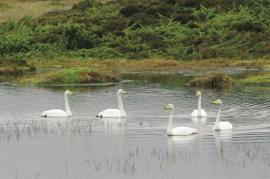
Tjeldstømarka
There is no place in Hordaland where there are so many over-wintering song swans as in Tjeldstømarka. And there are few places in the county that have had this birdfowl as a guest for as long.


Fitjar- the King's farm
In front of Fitjar Church there is a memorial stone, sculpted by Anne Grimdalen and erected in 1961, for the thousand-year memorial of one of the most dramatic events in Norway’s history, the Battle of Fitjar. This was the place where Norway’s king, Håkon the Good, suffered his fatal injury in the fight with Eirik’s sons, probably in the year 961.

Fitjarøyane
If we study the group of islands south of Selbjørns Fjord from the air or on a sea map, we will notice that many of the islands are elongated and lie systematically in rows. The islands are divided by long sounds, for example Trollosen, Nuleia and Hjelmosen, which are oriented in a south-southeast to north-northwesterly direction.


Rimbareid- Vestbøstad
At nesting time you cannot avoid hearing the calls of the curlew or the snipe along the narrow road through the cultural landscape from Rimbareid to Vestbøstad. And on late summer evenings, the intense song of the sedge warbler rings out over the two characteristic tarns in the area.

