- Remove Dialects and arts filter Dialects and arts
- Remove Industry, Energy and Natural Resources filter Industry, Energy and Natural Resources
- Remove Landscape filter Landscape
- Remove Literature filter Literature
- Remove Seabirds filter Seabirds
- Remove Wetland filter Wetland


Vinnesleira
Bays that are shallow far out into the sea, with fine sand and clay, are rare in Hordaland. Where they are found, the reason is usually that the edge of the glacier made smaller advances or stopovers when it calved back at the end of the last Ice Age. This is what happened at Vinnesleira.

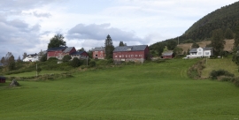
Bjørsvik
The industrial settlement Bjørsvik

Toska
The peat bogs on Toska have been mined for peat since 1946, when the island got electricity. In this treeless coastal landscape, peat was the most important source of energy, and this took quite a toll on the bogs.

Etnedeltaet
During the latter half of the 1900s the big natural river deltas on Westland disappeared. Until the 1980s there was still a small, but significant remnant of the original river delta from the Etneelva river, but today most of this, too, is industrial land.

Rekvesøyane
The sediment that was deposited from the river Dyrvo has created the fan-shaped delta Rekvesøyane. The bit of land farthest out toward the water gets periodically flooded, especially during snow melt and after periods of much rain.
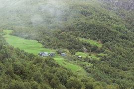
Tangarås
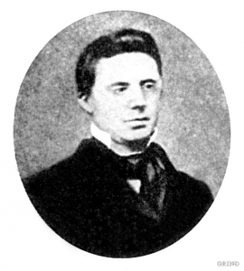
From his loft window on the doctor’s farm at Tangarås the young Hans Ernst Kinck had a view of the fjord and the Mauranger mountains. The fjord settlements in West Norway made a strong impression on the young boy when his family moved from Setesdal, from “the stifling mystique of the ballad”, to Strandebarm in 1876. The new district doctor bought the old captain’s farm at Tangarås, which had for some time been a military head farm after Håbrekke further into the settlement.

