- Remove Museum filter Museum
- Remove Farm sites filter Farm sites
- Remove Sunnhordland filter Sunnhordland
- Remove Hardanger og Voss filter Hardanger og Voss
- Remove Place filter Place
- Remove Large landforms filter Large landforms

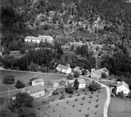
Rosendal Barony
The Barony of Rosendal lies in the grounds of the old noble estate of Hatteberg, on the north side of the Hatteberg river, around one kilometre up from the sea. The three noble estates Seim, Mel and Hatteberg constituted the core of the large estate taken over by Ludvig Rosenkrantz in 1662, after he was married to Karen Mowat in 1658.

Bondhusdalen
The Bondhus area in Maruanger has been a magnet for tourists ever since the stream of tourists to Norway's west coast began in the middle of the 1800s. The magnificent landscape with the "ice trail" up to Bondhusvatnet Lake, the ice falls from Bondhusbreen glacier and Keisarstigen trail up to Folgefonna are still popular tourist attractions.
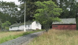
Rød
In 1969 Sigurd and Margreta Dønhaug donated a collection of around 170 historical cultural objects to Kvinnherad municipality. They wanted their gift to become the start of a farm collection in Uskedalen. And that is what happened.


Ulvanosa
Some mountains have rounded shapes, while others have steep slopes and sharp edges. Ulvanosa (1246 mos.) has both. The forms reflect the type of bedrock below, and the forces that were in effect when they were formed.

Vik
The farm Vik in Jondal has been one of the earliest settled farms in Jondal; a good and fertile farm east of the river. Legends hold that mighty men have lived in Vik, and it is easy to imagine that the farm may have been a chieftain’s seat for some time.

Hjølmo
In the steep hillside in Hjølmodalen, a small side valley from Øvre Eidfjord (Upper Eidfjord), which has been a key entrance to the Hardanger Plateau, the hamlet of old farmhouses still lie clustered together. The yard is empty today, some of the houses are used in the summer, but the grass grows round all the corners.

Kjeåsen
High up above the fjord, at a height of 600m lie the two holdings at Kjeåsen. Today you can drive there by car, through a new tunnel that the power engineers in Sima have drilled. Until 1974 the only road went up the steep hillside, along iron bolted ladders across dizzying rocks – a road for the strong at heart.

Måbø
Måbø is the uppermost farm in Måbødalen. This narrow and steep mountain valley has been one of the routes from the fjord communities up to the mountain plateau from times immemorial. We are not certain of the meaning of the name Måbø. Perhaps it has its origin in an Old Norse male name Mávi, from the name for seagull, már. The last syllable “bø” means farm. Today Måbø gives us a compact close-up of the subsistence economy: the small farm with the clearance piles, stone walls and a lane that guided the animals into the yard, at the foot of the great mountain expanse.

