- Remove Vernacular arts filter Vernacular arts
- Remove Farm sites filter Farm sites
- Remove Place filter Place
- Remove Road constructions filter Road constructions

Salhusfjorden
When the debate about building a pontoon bridge over Salhus Fjord was raging, some were afraid that the bridge would disrupt the ecology of the fjord system inside. The worst predictions did not prove true, but it is easy to see that there was a change: the Puffins have gotten a new food platter after the Nordhordaland bridge was built. Its favourite meal, mussels, thrive on the pontoons that are the foundation for the bridge.

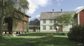
Bolstad
The village at Bolstadøyri acquired its structure around the middle of the 1800s, but from the old days there has been a meeting place here; court location and trading post. The guesthouse place stems from the second half of the 17th century, and in the previous century Bolstadøyri was one of the largest rural trading posts in Nordhordland.
Fjose
The farm Fjose lies uppermost in Tjukkebygdi, one of the good grain farms on the sunny side here. The woodcarver Styrk Fjose (1873-1937) came from this farm, which is now protected as a cultural heritage.


Kjeåsen
High up above the fjord, at a height of 600m lie the two holdings at Kjeåsen. Today you can drive there by car, through a new tunnel that the power engineers in Sima have drilled. Until 1974 the only road went up the steep hillside, along iron bolted ladders across dizzying rocks – a road for the strong at heart.

Hjølmo
In the steep hillside in Hjølmodalen, a small side valley from Øvre Eidfjord (Upper Eidfjord), which has been a key entrance to the Hardanger Plateau, the hamlet of old farmhouses still lie clustered together. The yard is empty today, some of the houses are used in the summer, but the grass grows round all the corners.

Måbø
Måbø is the uppermost farm in Måbødalen. This narrow and steep mountain valley has been one of the routes from the fjord communities up to the mountain plateau from times immemorial. We are not certain of the meaning of the name Måbø. Perhaps it has its origin in an Old Norse male name Mávi, from the name for seagull, már. The last syllable “bø” means farm. Today Måbø gives us a compact close-up of the subsistence economy: the small farm with the clearance piles, stone walls and a lane that guided the animals into the yard, at the foot of the great mountain expanse.

Agastølen
Whoever wanders the mountain plateau will form time to time hit upon old mountain summer farms, with solid old stone sheds, half sunk into the ground; a building tradition that has roots into prehistoric times. When we have been satiated with untouched Nature, it is somewhat comforting to come upon the old mountain chalets - they represent a type of human encroachment that we not only accept, but appreciate. They arouse a feeling of recognition and are a distinct witness to how people in the rural communities have made use of even the most remote resources.

Einstapevoll- the farm
Einstapevoll (from einstape: “bregne” (fern)) lies on the west side of the Tittelsnes peninsula. Up to 1831 the farm was a vicarage belonging to Stord parish. The priests had leasing rights. Land rent and other fees from the farm was part of their salaries.

Haugsbø
The single unit farm without a road to it, Haugsbø, is situated on the east side of the Tittelsnes peninsula facing Ålfjorden. As far back as the Middle Ages the farm has probably belonged to Stord Parish, up to the 1800s. In 1590 it was thought to be abandoned, but in 1601 Mickel Hougsbøe paid a tithe on the farm.

