- Remove Vernacular arts filter Vernacular arts
- Remove Defense filter Defense
- Remove Place filter Place
- Remove Fisheries filter Fisheries

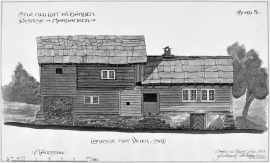
Espevær- the Trading Post
In the sea west of Bømlo lies Espevær, half an hour’s rowing trip across the sound from Vespestadvågen. This is a well-run and well-maintained local community, established on the back of the rich herring fisheries in the 1850s. It is fishermen, skippers and the tradesmen who have made their mark on the culture in Espevær, with their contacts to the south towards Haugesund and across the North Sea to the British Isles.
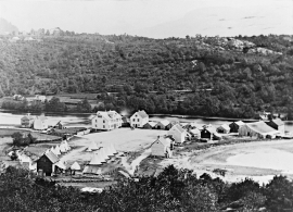
Osøyro
The coastal settlement of Os begins to take form in the middle of the 1800s. This is when craftsmen and traders begin to settle at the river delta.
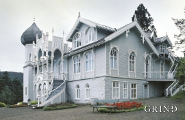
Lysøen
Lysøen, this fairytale castle with its Russian-inspired onion dome on the corner turret, stands as a reminder of the diversity of the period called Historicism and a monument to a versatile artist; a key figure in the Norwegian National Romanticism.
Ramsøy
“At thick of night a thundering knock on the door; the man in the house wakes up, jumps out and demands: Who cries? Yes, now you must out, the beacon shines on Høgenut. And in the same breath, every man knew that strife had hit the land.”

Tælavåg
Tælavåg has a significant place in the history of the German occupation in WWII. The small community by the sea, where for centuries people had made a living from farming and fishing in harmony with the natural resources, in 1942 became the victim of German reprisals without their equal in Norwegian war history. The collection of war histories in Tælavåg provides us with a close-up of the dramatic events.

Skogsvåg
Kval i våg! Når det ropet gjekk, var det berre å få ut den kraftige kvalnota til å stengja vågen med, og så kunne veidinga ta til. I uminnelege tider har det vore drive kvalveiding i Skogsvågen.

Håøy
Håøy lies centrally in one of the main shipping lanes going into Bergen --- with Håyøsund on the south side facing Meland, and Hagelsundet facing Lindåslandet. Names like Nordfarskista and Nordfarsskorane explain things. The strategic position was important in Viking times and it has been important in our days too. The beacon on Håøy can have been built in the establishment of the coastal administration in Håkon the Good’s time, about 950 AD. The defence structure of which we say remains on Håøy Summit held a critical position during Norwegian neutrality during the First World War. The defence structure was taken down in 1957.

Fosnstraumen
At the southern end of the bridge between Radøy and Fosnøy archaeologists found an unusual Stone Age settlement. There was a thick “cultural layer” here with the remains of the waste dumps of a hunting people. The place was called Kotedalen. Here they came, one group after the other, and settled for some weeks, some months, or maybe years before they went on, leaving the settlement deserted. Time after time it happened. At least 16 settlement phases have been identified, stretching over 5,500 years.

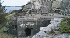
Vinappen
Vinappen lies on a low hill to the very west on the island. Here you have an amazing panorama of the sea. Originally the area was grazing land for cattle, but this changed when the Germans occupied the island. Just before WWII there was a small bearing station, used by the Norwegian Coast Artillery in connection with exercises at sea.