- Remove Small landforms filter Small landforms
- Remove Tourism filter Tourism
- Remove Sediments filter Sediments

Godøysund
The old hostelry centres were strategically placed with good harbours and anchoring conditions where people travelled. GODØYSUND, or Gøysundet, as it was called, was in the middle of Tysnes Parish, with easy access from the sea, also for the local population. Gøysundet is amongst the oldest hostelries in Sunnhordland.
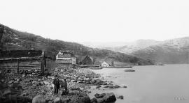
Utne
When sergeant Peder Larsen Børsem from Strandebarm was “demobilised” in 1721, following the large Nordic War, he married the Bergen lady Elisabeth Schrøder and settled as innkeeper at Utne with a letter of privilege from the county governor dated 29 October 1722.

Stalheim
Stalheim is situated between Stalheimsfossen and Sivlefossen, in a community with the farms Sivle and Brekke. The most likely explanation of the name is “the farm by Stadall”, from “standa” (stand), probably with background in the steep Stalheimskleivi. The farm has for a long time been divided into several units. At Stalheim there has been a transport exchange from the Middle Ages and the farm has been a postal farm since 1647.

Odda- The tourist town
The pioneering tourists in the 1830s-40s brought a momentum in the tourist traffic to the fjord and mountain country Norway. At the time Odda was a hidden Shangri-La at the bottom of Sørfjorden; the farm and the church on the green headland at the fjord. But when the steamship traffic opened the fjord landscape for tourism, in a few years Odda parish in Søndre Bergenhus County became the focal point for travellers in West Norway.

Fjøsanger
Fjøsanger is known among ice age researchers from around the world. Under an excavation in 1975-77, geologists from the University of Bergen found layers from the last interglacial, ca. 115 000 to 130 000 years old.

The village of Etne
Much of the sand and gravel that the town of Etne is built on was laid down at the end of the Ice Age and is evidence of melting glaciers and roaring meltwater rivers. The uncompacted material in the big terraces leave their unmistakeable mark on the wide elongated valleys.

Skånevik- moraine
In Skånevik there are marks left from the ice edge that advanced during the thousand-year cold spell (Younger Dryas) that marked the end of the Ice Age roughly 11 500 years ago. The glacier first proceeded out into Åkra Fjordand and around Vannes and thereafter sent an arm in toward Skånevik. Here, the glacier lay down an end moraine up against the mountainside.

Mosnes
The permanently-protected Mosneselva River, with its meltwater from Folgefonna, runs out into Åkra Fjord by the roadless and uninhabited Mosnes. Those who once lived here were forced to surrender to the ravages of Nature. In the autumn of 1962 there was a flood so great that the people were driven from their farms.


Ølve
Ølve has a special soil type. Here one finds an extra hard clay soil. This is especially noticed by those who work with excavating for building foundations and the like. Often it is necessary to use especially big digging machines and sometimes even dynamite in order to break up the compact masses. The reason for this is the growth of the glaciers toward the end of the Ice Age: The clay, that was first deposited in front of the glacier, came under great pressure when the glacier later grew and slid out over the clay.

