- Remove Museums, nature conservation, cultural heritage filter Museums, nature conservation, cultural heritage
- Remove Sunnhordland filter Sunnhordland
- Remove Hardanger og Voss filter Hardanger og Voss
- Remove Settlements, Villages, Towns filter Settlements, Villages, Towns
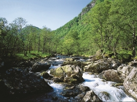
Stølsdalen
The grey alder forest down by the river in Stølsdalen is full of life. The many birds are very busy finding enough to eat from day to day – but the biggest challenge is to make oneself heard above the roar of the Stølselva River.
Helleland
The old “recorder residence” at Helleland has been both residence for the district recorder and officer’s residence. The main building, which came under protection in 1924, was built in 1764 by the curate Christian Heiberg. When he was appointed parish priest in Jølster, he sold the farm to the state employee Geelmuyden, who resold the farm to Hans De Knagenhielm in 1774. He was the head of “Søndre Hardangerske kompani” (a local army division).

Bru
Bruosen is one of the few river harbours in the county. As landing place for the churchgoers, this place and the boatshed environment follow a tradition that goes back to the Middle Ages, but the country store of today is much younger.


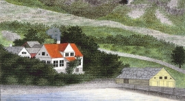
Hjølmo
In the steep hillside in Hjølmodalen, a small side valley from Øvre Eidfjord (Upper Eidfjord), which has been a key entrance to the Hardanger Plateau, the hamlet of old farmhouses still lie clustered together. The yard is empty today, some of the houses are used in the summer, but the grass grows round all the corners.

Måbø
Måbø is the uppermost farm in Måbødalen. This narrow and steep mountain valley has been one of the routes from the fjord communities up to the mountain plateau from times immemorial. We are not certain of the meaning of the name Måbø. Perhaps it has its origin in an Old Norse male name Mávi, from the name for seagull, már. The last syllable “bø” means farm. Today Måbø gives us a compact close-up of the subsistence economy: the small farm with the clearance piles, stone walls and a lane that guided the animals into the yard, at the foot of the great mountain expanse.

Agastølen
Whoever wanders the mountain plateau will form time to time hit upon old mountain summer farms, with solid old stone sheds, half sunk into the ground; a building tradition that has roots into prehistoric times. When we have been satiated with untouched Nature, it is somewhat comforting to come upon the old mountain chalets - they represent a type of human encroachment that we not only accept, but appreciate. They arouse a feeling of recognition and are a distinct witness to how people in the rural communities have made use of even the most remote resources.
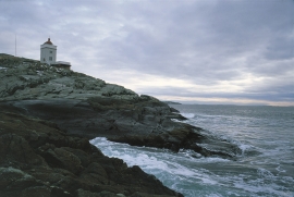
Ryvarden
In the Islandic Landnåmabok there is a story that the explorer Floke Vilgjerdsson built a cairn “where meetest Hordaland and Rogaland” and the cairn was named Flokavarði. Tormod Torfæus wrote in Historia Norvegica (1711) that this name was still in use, but that the farmers used “Ryvarden” for the same place.

Einstapevoll- the farm
Einstapevoll (from einstape: “bregne” (fern)) lies on the west side of the Tittelsnes peninsula. Up to 1831 the farm was a vicarage belonging to Stord parish. The priests had leasing rights. Land rent and other fees from the farm was part of their salaries.

Haugsbø
The single unit farm without a road to it, Haugsbø, is situated on the east side of the Tittelsnes peninsula facing Ålfjorden. As far back as the Middle Ages the farm has probably belonged to Stord Parish, up to the 1800s. In 1590 it was thought to be abandoned, but in 1601 Mickel Hougsbøe paid a tithe on the farm.

