- Remove Midthordland filter Midthordland
- Remove Archaeological findings filter Archaeological findings
- Remove Hydro power filter Hydro power
- Remove Maritime environments filter Maritime environments
- Remove Large landforms filter Large landforms
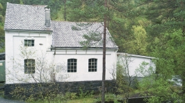
Gåssand
The 28th November 1914 was a day to remember for the Os inhabitants. This was the day they could turn the switch on the wall and have electric light in their houses. It was like opening the door on the future when the power station at Gåssand was put into operation.

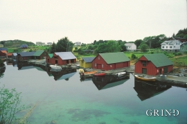
Notaholmen
The fishnet shed at Notaholmen stands as a reminder of the days when people used to row out on the fjord to set their nets. On Notaholmen the nets were dried, repaired and tanned. And it was a great advantage to store them in a place inaccessible for rats and mice.

Golta- Long house
In the years between the wars a major registration of houses and house costumes, house construction methods, fireplaces and forms of housing clusters was started in West Norway – an ambitious mapping of everything that came under the name “Registration of Culture and Geography in West Norway”. One of the places of which material was gathered in 1938 was an old multi-room house at Golta; new and interesting material for the researchers from the Historical Museum, but well known within the local building tradition through several generations.

Landro
Landro has been the largest estate on Sotra, including 15 farms with reasonable conditions for agriculture. Their boathouses have had an excellent harbour in Landrovågen. Landro thus has been a good basis for the combination of agriculture and fishing.

Høybøen
In connection with the planned developments in the oil sector at Vindenes around 1980, excavations were carried out under the auspices of Bergen Historical Museum. Exceptionally interesting traces of an old farm at Høybøen then came to light. These were the remnants of a farm where there had been two houses containing several rooms.
Herdlevær
Herdlevær lies on one of the small islands west of Hjeltefjorden, facing the North Sea and the big ocean. Today you may arrive there by car. The numerous islands are linked together by elegant bridge spans made of concrete. Fifty years ago it was half a day’s journey to get to Herdlevær from the mainland by your own rowing boat or ferry.

Hjelmo
On the farm Hjelmo, furthest north in Øygarden, in the innermost part of a long bay, there is a fine boatshed collection with a church beside it. From times immemorial this has probably been the fish-shed location for these farm units and this was also the landing place for the churchgoers.

Åsane
Most associate Åsane with ridges, naturally enough (the Norwegian word for "ridge" is "Ås"). A lesser noticed trait in the landscape are the unusual flat areas that lie between the ridges. The Dalselva River, which was channeled at the end of the 1950s, runs down only 2.5 metres from Lake Langavatnet by Vågsbotn to Flatevad, where it goes over into rapids by Fossekleiva. The layers of gneiss stand nearly vertically, and the mountain surface is so even that one might think it had been planed with a planer.

Sandviksfjellet
On Sandviksfjellet there are old boulders that have been made into mountains. The stones have been stretched out or squeezed together between huge slabs of rock, during slow, but powerfulprocesses of transport. This conglomerate shows, in quite a special way, the enormous powers that were active during the collision between Norway and Greenland over 400 million years ago.

Isdalen
The valley on the inside of the Svartediks dam, a five minutes' bus ride from Bergen centre, is often referred to by Bergen folk as Isdalen ("Ice Valley") - justifiably, since the area could have been described in textbooks for its ice-carved land forms. The glacier's polishing over ca. 40 ice ages has created a magnificient landscape. The original ice valley climbs up behind Ulriken at the end of Svartediket.

