- Remove Article filter Article
- Remove Standard side filter Standard side
- Remove Churches filter Churches
- Remove Place filter Place
- Remove Faults filter Faults


Stall
The Bergen Arcs have an unusually sharp boundary to the bedrock in the east. Geologists think that this was caused by movements in the earth's crust during the Devonian Period. Then, the Bergen Arcs on the Lindås peninsula sank a whole 10 kilometres in relation to the Precambrian basement gneisses on the east side of Fens Fjord and Aust Fjord.

Tyssøy
B.E.Bendixen, who has written about “The Churches in Søndre Bergenhus Amt”, believed even around 1900 that there was evidence at Tyssøy of the church or the chapel of the Holy Ludvig (Louis). Two large stone blocks had lain in the western wall of the church’s nave, and this wall showed a length of 16 meters in the terrain.
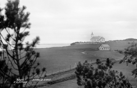
Herdla Church
A letter from the Pope Eugenius 3 in 1146 mentions St. Nikolaus church at Herdla. This church belonged under Munkeliv monastery, which was founded in Bergen by Øystein around 1110. The Herdla Church may stem from this time.

Haganes
The gneiss landscape west and north of Bergen viewed in profile can remind us of a saw blade of the kind that has long, slanted sides that get broken off shorter transverse sides. It has taken several hundred million years to file this saw blade, an enduring interplay between various geological processes.

Vatlestraumen
There are coal bits hidden in the sand under Vatlestraumen. These remains from a geological layer from the Jurassic Period were discovered when the undersea Bjorøy Tunnel was built in 1994. Oil- and gas reservoirs in the Troll Field in the sea west of Hordaland are from the same time. It is, nonetheless, quite surprising to find bedrock from dinosaur time inside of the outer islands of western Norway. On the Scandinavian mainland north of Denmark, there are only a very few places where one f inds rock from this time in earth history.


Fitjarøyane
If we study the group of islands south of Selbjørns Fjord from the air or on a sea map, we will notice that many of the islands are elongated and lie systematically in rows. The islands are divided by long sounds, for example Trollosen, Nuleia and Hjelmosen, which are oriented in a south-southeast to north-northwesterly direction.

