- Remove Modalen filter Modalen
- Remove Maritime environments filter Maritime environments
- Remove Austrheim filter Austrheim
- Remove Factories filter Factories
- Remove Stone age filter Stone age
- Remove Sund, frå 2020 del av nye Øygarden kommune filter Sund, frå 2020 del av nye Øygarden kommune
- Remove Bømlo filter Bømlo
- Remove Conservation area filter Conservation area

Otterstadstølen
Otterstadstølen lies in an idyllic grassy plain surrounded by rich forest, but also with high mountains close by. The mountainsides are steep and typical of this part of the county. The same cannot be said about the forest. This spruce forest has been able to develop freely for hundreds of years. Otherwise in the county, only Voss has spruce forest.

Goltasundet
For generations the land-seine was the most important tool for catching herring and mackerel, and therefore a suitable casting bay was worth its weight in gold. Goltasundet (the Golta sound) on Golta was such a place. Here the herring often drifted in and fantastic casts might be made here.


Siggjo
Siggjo is a cone-shaped, volcano-like mountaintop in the part of Hordaland where one finds the best preserved volcanic rocks. The rock types originate from one or several volcanoes that spewed out glowing lava and ash. But, the shape of the mountain, as it appears today, formed later and by completely different forces.
Skogafjellet
You have to travel to Scotland in order to find pine forests similar to those at Bømlo. The nearness to the sea has contributed in different ways to shaping one of the westernmost pine forests in Norway.


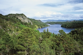
Stølsheimen
The large mountain area between Modalen, the Voss communities and Sogn is one of the finest mountain pasture areas in West Norway. In older times this area was called Steinslandsheimen, in our times it has acquired the name Stølsheimen. Power development and protection interests have been opposed here. The core area of Stølsheimen has now been protected as a landscape protection area, while some of the oldest mountain farms have been flooded. A register in the 1970s comprised almost 40 mountain farm settlements in the central area of Stølsheimen, belonging to Modalen, Høyanger and Vik municipalities.

Otterstad
Tthe Otterstad farms lie in the innermost part of Mofjorden, on the northwest side of the river. The row of stave-built boatsheds that belong to the farm were probably constructed a little after the middle of the 1800s. Both here and on the Mo side, the boatsheds were important storage places at the seashore; wood and other farm products intended for the town; corn and merchandise in return.

Krossøy
Furthest north in the island community Rongevær, at the entrance to Fensfjorden, lies Krossøy. Belonging to the farm are the islands of Krossøy, Husøy, Kårøy, Lyngkjerringa, Søre Kjerringa, Rotøy and Kuhovet. All of them have been inhabited. On Krossøy itself today there are four holdings. The marine use environment here is one of the best preserved along the West Norwegian coast.

