- Remove Quarns and mills filter Quarns and mills
- Remove Wetland filter Wetland
- Remove Faults filter Faults

Bjellandsvatnet
Lake Bjellandsvatnet is one of the richest wetland areas in Sveio. But, everything has its limit, and the supply of nutrients can be too much. This is what was about to happen in Lake Bjellandsvatnet.

Bjørsvik
The industrial settlement Bjørsvik

Etnedeltaet
During the latter half of the 1900s the big natural river deltas on Westland disappeared. Until the 1980s there was still a small, but significant remnant of the original river delta from the Etneelva river, but today most of this, too, is industrial land.
Fedje bog
The wild rabbit is really native to Northwest Africa, but the Ancient Romans introduced them to large parts of Europe. Not to Norway, rightly enough: the population on Fedje originated from 3-4 pairs that were brought here from the Shetland Isles in 1875, making this their first residence in the country.

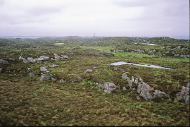
Fitjarøyane
If we study the group of islands south of Selbjørns Fjord from the air or on a sea map, we will notice that many of the islands are elongated and lie systematically in rows. The islands are divided by long sounds, for example Trollosen, Nuleia and Hjelmosen, which are oriented in a south-southeast to north-northwesterly direction.

Fossevatna
Fossevatna, some few kilometres north of Alversund, is one of the finest wetland areas in Lindås. Especially the birdlife has made this place well known. Throughout the year, one can make exciting bird discoveries. But, if you want to hear the flight games skal høre med fagredaktør Stein Byrkjeland of the Snipe, you should come here on a spring or summer evening.


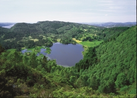
Granvinsvassdraget
After the ice age, Granvin Fjord reached all the way up under Skjervsfjossen waterfall. Just a thousand years later, as a result of the rising of the land after the ice melted, this whole inner part of the fjord freed itself of the sea and became Granvinsvatnet lake. In spite of this rise in elevation, this waterway is still navigable for fish: Sea trout have wandered into Granvinsvatnet in more recent times and evolved to become freshwater trout. And salmon and sea trout made the journey 13 kilometres up the Storelvi river.

Haganes
The gneiss landscape west and north of Bergen viewed in profile can remind us of a saw blade of the kind that has long, slanted sides that get broken off shorter transverse sides. It has taken several hundred million years to file this saw blade, an enduring interplay between various geological processes.

