- Remove Smallholdings filter Smallholdings
- Remove Sedimentary rocks filter Sedimentary rocks
- Remove Faults filter Faults
Finnås
At Flintaneset by Finnåsvika, in the centre of the municipality, we find the most beautiful and best preserved igneous rocks in western Norway. We must go to Hawaii or Island to find as fine structures as at Bømlo.

Fitjarøyane
If we study the group of islands south of Selbjørns Fjord from the air or on a sea map, we will notice that many of the islands are elongated and lie systematically in rows. The islands are divided by long sounds, for example Trollosen, Nuleia and Hjelmosen, which are oriented in a south-southeast to north-northwesterly direction.


Haganes
The gneiss landscape west and north of Bergen viewed in profile can remind us of a saw blade of the kind that has long, slanted sides that get broken off shorter transverse sides. It has taken several hundred million years to file this saw blade, an enduring interplay between various geological processes.

Holmengrå
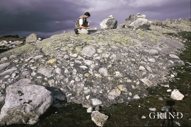
Holmengrå is the only place in Hordaland where we find traces of the abrasion that is supposed to have transformed Western Norway from a Himalaya-like high mountain landscape during the earth's Paleozoic Era, to a flat lowlands terrain during the Mezosoic Era. Just 400 million years ago, large and small stones plummeted down from the high mountains. Some of these stones became incorporated into the conglomerate bedrock on Holmengrå.

Krokavatnet
On Sunday the 29th of January, 1989, at 17:38 o'clock, Etna shook. The earthquake, with its epicentre ca. 9 kilometres south of Etne centre, had a strength of 4.2 on the Richters scale. This could be felt over large parts of West Land, especially in the areas around Åkra, Etne, Hardanger Fjord and Sauda Fjord. The earthquake was the largest that has ever been measured in Hordaland.


Sandviksfjellet
On Sandviksfjellet there are old boulders that have been made into mountains. The stones have been stretched out or squeezed together between huge slabs of rock, during slow, but powerfulprocesses of transport. This conglomerate shows, in quite a special way, the enormous powers that were active during the collision between Norway and Greenland over 400 million years ago.

