- Remove Smallholdings filter Smallholdings
- Remove Factories filter Factories
- Remove Faults filter Faults

Alvøen
Alvøen is one of the oldest industrial places in Norway. As early as the 1620s a gunpowder mill was built here. The place itself was well situated for industrial activity, lying only 100 m from the waterfall, which provided power for the mill, and a good harbour wherefrom the products were shipped. The success of the gun-powder mill varied in the 1600s and 1700s, but what made Alvøen best known was its paper production.

Bjørsvik
The industrial settlement Bjørsvik


Fitjarøyane
If we study the group of islands south of Selbjørns Fjord from the air or on a sea map, we will notice that many of the islands are elongated and lie systematically in rows. The islands are divided by long sounds, for example Trollosen, Nuleia and Hjelmosen, which are oriented in a south-southeast to north-northwesterly direction.


Haganes
The gneiss landscape west and north of Bergen viewed in profile can remind us of a saw blade of the kind that has long, slanted sides that get broken off shorter transverse sides. It has taken several hundred million years to file this saw blade, an enduring interplay between various geological processes.
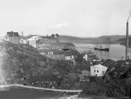
Knarrevik
Having passed well over the bridge across to Sotra you pass an industrial plant surrounded by a budding community; the mineral mill of A/S Norwegian Talc. Some of the buildings seem to have been erected in the early part of the 20th century. They are remnants of a grand industrial plant from the former boom time in the country – the economic upswing after WWI.

Krokavatnet
On Sunday the 29th of January, 1989, at 17:38 o'clock, Etna shook. The earthquake, with its epicentre ca. 9 kilometres south of Etne centre, had a strength of 4.2 on the Richters scale. This could be felt over large parts of West Land, especially in the areas around Åkra, Etne, Hardanger Fjord and Sauda Fjord. The earthquake was the largest that has ever been measured in Hordaland.

Odda- The industrial town
In 1908 the new power station in Tyssedal was completed. A/S Tyssefaldene provided power for the carbide and cyanide factory that was built in Odda. This signalled a new era.

