- Remove Music filter Music
- Remove Waterfalls filter Waterfalls
- Remove Faults filter Faults

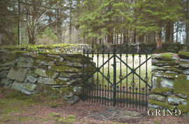
Botnen
Fyksesundet and Botnagrenda present a fine experience of the landscape and cultural history; a geographically isolated local settlement with extensive cultural contact with the outside world.

Fitjarøyane
If we study the group of islands south of Selbjørns Fjord from the air or on a sea map, we will notice that many of the islands are elongated and lie systematically in rows. The islands are divided by long sounds, for example Trollosen, Nuleia and Hjelmosen, which are oriented in a south-southeast to north-northwesterly direction.

Fossen Bratte
The steep drop by Fossen cliff has been the biggest challenge for those who wished to make a road over Kvamskogen through the years. Leave the car by the monument on the old road and take a walk down to the bend by the waterfall that Bergen-folk call "The bridal veil". Why is there a waterfall just here?


Haganes
The gneiss landscape west and north of Bergen viewed in profile can remind us of a saw blade of the kind that has long, slanted sides that get broken off shorter transverse sides. It has taken several hundred million years to file this saw blade, an enduring interplay between various geological processes.

In Memory of Fartein Valen
“Fartein Valen is the key figure within newer Norwegian music. Not by way of being more popular than other younger composers, but because he aims at things higher, which he is fully confident of being able to reach since he commands all techniques. But there is a price to pay for reaching above the ordinary, and there is a price to pay for demanding more than the ordinary from the listeners. This is something Valen has experienced”.

Krokavatnet
On Sunday the 29th of January, 1989, at 17:38 o'clock, Etna shook. The earthquake, with its epicentre ca. 9 kilometres south of Etne centre, had a strength of 4.2 on the Richters scale. This could be felt over large parts of West Land, especially in the areas around Åkra, Etne, Hardanger Fjord and Sauda Fjord. The earthquake was the largest that has ever been measured in Hordaland.

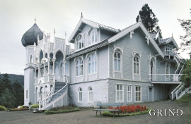
Lysøen
Lysøen, this fairytale castle with its Russian-inspired onion dome on the corner turret, stands as a reminder of the diversity of the period called Historicism and a monument to a versatile artist; a key figure in the Norwegian National Romanticism.

