- Remove Museum filter Museum
- Remove Place filter Place
- Remove Sunnhordland filter Sunnhordland
- Remove Hardanger og Voss filter Hardanger og Voss
- Remove Boat- and shipyards filter Boat- and shipyards
- Remove Large landforms filter Large landforms

Berge
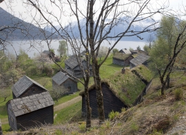
Down by the fjord on the farm Berge in Tørvikbygd, is Stekkavika – a sheltered eastward facing harbour, protected against the fjord by headlands and rocks, even manifest in the name. Here is also a comprehensive milieu of coastal industry, with boathouses and sea-sheds that belong to the farms Berge, Heradstveit and Halleråker. Belonging to the farm Berge there is also a mill-house, circular saw, workshop for sloop building, and – a little further up into the woods – the old water-powered sash-saw.


Bondhusdalen
The Bondhus area in Maruanger has been a magnet for tourists ever since the stream of tourists to Norway's west coast began in the middle of the 1800s. The magnificent landscape with the "ice trail" up to Bondhusvatnet Lake, the ice falls from Bondhusbreen glacier and Keisarstigen trail up to Folgefonna are still popular tourist attractions.


Fitjarøyane
If we study the group of islands south of Selbjørns Fjord from the air or on a sea map, we will notice that many of the islands are elongated and lie systematically in rows. The islands are divided by long sounds, for example Trollosen, Nuleia and Hjelmosen, which are oriented in a south-southeast to north-northwesterly direction.


Huglo
The majority of Huglo is bare rock. A bit of dwarf pine forest is the only vegetation able to put down roots. Along the west- and east sides, to the contrary, the landscape is unusually green and lush. The reason lies both in the bedrock and in the ice that covered the area 12 000 years ago.

Hårteigen
Hårteigen, «the grey signpost», as the name suggests, is a landmark for mountain hikers on the western plateau. The piece of mountain is also a monument for the mighty rock layers that once covered the entire plateau.

Kattnakken–Stovegolvet
The highest mountainous area on Stord, including Kattnakken, Midtfjellet and Stovegolvet, has more in common with the mountainous terrain on the mainland than in the low coastal landscape of Sunnhordland. The volcanic bedrock together with the erosive powers of nature has resulted in a unique plateau landscape.

