- Remove Basement rocks filter Basement rocks
- Remove Midthordland filter Midthordland
- Remove Hydro power filter Hydro power
- Remove Place filter Place
- Remove Maritime environments filter Maritime environments
- Remove Museum filter Museum

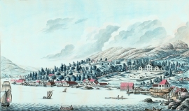
Alvøen
Alvøen is one of the oldest industrial places in Norway. As early as the 1620s a gunpowder mill was built here. The place itself was well situated for industrial activity, lying only 100 m from the waterfall, which provided power for the mill, and a good harbour wherefrom the products were shipped. The success of the gun-powder mill varied in the 1600s and 1700s, but what made Alvøen best known was its paper production.


Bryggen
In the 1300s Bergen was a trading centre of European dimension. The town is thought to have had around 7000 inhabitants and was the largest and most important in the country. In a European context it was an average size town. At this time the most tightly built town area was still mostly east of Vågen from Holmen in the north to Vågsbotn in the south. Already in medieval times, latest in the 1340s, this area was called Bryggen.
Damsgård
As a fairytale castle Damsgård Hovedgård lies on the slope rising up from the Puddefjord. The old connection between the farm and the sea, as we see it on Dreier’s prospectus from 1810, has been broken up by roads and encroachments in the building mass. But the main building itself is a central monument in Norwegian architecture from the 1700s – one of the finest representatives for the rococo period, with a magnificent and rich décor both in its interior and exterior.

Frøland
Much rain, a steep drop and nearness to Bergen meant that the power-making potential of the Samnanger water system was exploited early. Samnanger was thus one of the first power-producing municipalities in western Norway. With its subsequent expansion and new power stations, about 400 gigawatts of electricity per hour were produced on average each year. This is enough to meet the energy needs of 25,000 households.

Golta- Gneiss
Over thousands of years, autumn storms and strong land-driving winds have cleaned the bare rocks of Golta. The waves can beat far in over land and make it dangerous to walk along the shoreline. When the storms have calmed, the results of their work comes into view.

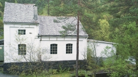
Golta- Long house
In the years between the wars a major registration of houses and house costumes, house construction methods, fireplaces and forms of housing clusters was started in West Norway – an ambitious mapping of everything that came under the name “Registration of Culture and Geography in West Norway”. One of the places of which material was gathered in 1938 was an old multi-room house at Golta; new and interesting material for the researchers from the Historical Museum, but well known within the local building tradition through several generations.

Goltasundet
For generations the land-seine was the most important tool for catching herring and mackerel, and therefore a suitable casting bay was worth its weight in gold. Goltasundet (the Golta sound) on Golta was such a place. Here the herring often drifted in and fantastic casts might be made here.
Gåssand
The 28th November 1914 was a day to remember for the Os inhabitants. This was the day they could turn the switch on the wall and have electric light in their houses. It was like opening the door on the future when the power station at Gåssand was put into operation.

Haganes
The gneiss landscape west and north of Bergen viewed in profile can remind us of a saw blade of the kind that has long, slanted sides that get broken off shorter transverse sides. It has taken several hundred million years to file this saw blade, an enduring interplay between various geological processes.

