- Remove Basement rocks filter Basement rocks
- Remove Midthordland filter Midthordland
- Remove Hydro power filter Hydro power
- Remove Place filter Place
- Remove Pollution and environment filter Pollution and environment
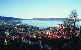
Byfjorden
Swimming and fishing is fully possible in Byfjorden (By Fjord). The water is of good quality most places, after considerable resources have been used in past years for clean-up. But, past sins still lie in the mud on the sea bottom. Fish that live in direct contact with the bottom sludge should not be eaten.

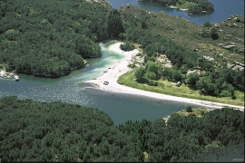
Fjell river network
There are many river networks out by the coast and they tend to be small and unassuming. The farmer has relied upon the watercourses to run his mill and saw, and it may be that the trout have given him a good source of food in years when the ocean fish failed. In our time, these river networks are being rediscovered for their value in recreation and outdoor life, and several places, tourist trails have been built in order to fully enjoy them.

Frøland
Much rain, a steep drop and nearness to Bergen meant that the power-making potential of the Samnanger water system was exploited early. Samnanger was thus one of the first power-producing municipalities in western Norway. With its subsequent expansion and new power stations, about 400 gigawatts of electricity per hour were produced on average each year. This is enough to meet the energy needs of 25,000 households.

Golta- Gneiss
Over thousands of years, autumn storms and strong land-driving winds have cleaned the bare rocks of Golta. The waves can beat far in over land and make it dangerous to walk along the shoreline. When the storms have calmed, the results of their work comes into view.
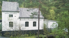
Gåssand
The 28th November 1914 was a day to remember for the Os inhabitants. This was the day they could turn the switch on the wall and have electric light in their houses. It was like opening the door on the future when the power station at Gåssand was put into operation.

Haganes
The gneiss landscape west and north of Bergen viewed in profile can remind us of a saw blade of the kind that has long, slanted sides that get broken off shorter transverse sides. It has taken several hundred million years to file this saw blade, an enduring interplay between various geological processes.

Kollevågen
From 1938 until 1975 there was a large amount of trash dumped in Kollevågen. A lot of the garbage from the city of Bergen ended up here. The dump was up to 20 metres high, and much got dumped under water in the bay. When the dump was closed, the time had come to make good on a municipal promise to make the place into a recreation area. In 1978, nets and earth were laid over the dump, and afterward it was sowed with seeds. This was quite successful, and In 1983, the recreation area was opened.

Nordåsvatnet
The Post-war Era came to Fana with its population growth and modern sanitary equipment. This had nearly catastrophic consequences for Nordåsvatnet as a recreational area. After the runoff water got re-directed to deeper water, and later also to the fjord outside, Lake Nordås won back both its swimming guests and its sports fishermen.

Toftestallen
The large coastal waves that crash down on the islands west in the sea gather their energy from storms and winds all the way out in the North Atlantic Ocean. The most common place of origin is nonetheless the North Sea. When these waves break over the skerries and islets along the shore, or on the rocky outermost islands, their energy is released. This takes the form of turbulence in the water and sea spray up on land. Can the enormous energy contained in the waves be exploited?

