- Remove Small landforms filter Small landforms
- Remove Middle age filter Middle age
- Remove People and Society filter People and Society
- Remove Defense filter Defense
- Remove Sunnhordland filter Sunnhordland
- Remove Dialects and arts filter Dialects and arts
- Remove Chieftains and royal lines filter Chieftains and royal lines
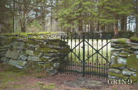
- Remove Cemeteries filter Cemeteries
- Remove Landscape filter Landscape
- Remove Igneous rocks filter Igneous rocks

Fitjarøyane
If we study the group of islands south of Selbjørns Fjord from the air or on a sea map, we will notice that many of the islands are elongated and lie systematically in rows. The islands are divided by long sounds, for example Trollosen, Nuleia and Hjelmosen, which are oriented in a south-southeast to north-northwesterly direction.

Mosnes
The permanently-protected Mosneselva River, with its meltwater from Folgefonna, runs out into Åkra Fjord by the roadless and uninhabited Mosnes. Those who once lived here were forced to surrender to the ravages of Nature. In the autumn of 1962 there was a flood so great that the people were driven from their farms.

Skorpo
Skorpo - Polished by glaciers and meltwater

Støle
High above the sea and the beach flats, on one of the wide terraces shaped by the sea and the ice, lies the farm Støle (Stødle). The Old Norse name of Studla is derived from studill “support, shelf”. As far back as Viking times Støle has been a chieftain’s farm, a good farm on the plains formed by the moraine masses.

Ulvanosa
Some mountains have rounded shapes, while others have steep slopes and sharp edges. Ulvanosa (1246 mos.) has both. The forms reflect the type of bedrock below, and the forces that were in effect when they were formed.

