
Bondhusdalen
The Bondhus area in Maruanger has been a magnet for tourists ever since the stream of tourists to Norway's west coast began in the middle of the 1800s. The magnificent landscape with the "ice trail" up to Bondhusvatnet Lake, the ice falls from Bondhusbreen glacier and Keisarstigen trail up to Folgefonna are still popular tourist attractions.

Bordalsgjelet
Deep down between the stone polished phyllite bedrock in Bordalsgjelet canyon, there is a cascading river. In close cooperation with hard polishing stones, the water has carved into the bedrock for thousands of years - and is still doing so today.


Botnen
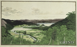
Fyksesundet and Botnagrenda present a fine experience of the landscape and cultural history; a geographically isolated local settlement with extensive cultural contact with the outside world.

Buardalen Valley
Buarbreen glacier was one of the first destinations during the period of increasing tourism in Odda in the 1800s. Foreigners came by the thousands, mostly Englishmen and Germans, to the magnificent landscape in front of the glacier. Back at the hotel in Odda they could enjoy drinks containing ice from the glacier.


Cultural Heritage and Cultural Landscapes
The development which culminated in the great west Norwegian clustered communities in the 18th and 19th centuries, such as we see at Havrå on Osterøy Island, actually first came into being in Viking times, with an incipient division of the farms into smaller units.

Dyrdal
If you journey along Austfjorden, you at the same time turn the pages of time back through Ice Age history. The landforms show how the landscape has developed gradually as the glaciers have grown - and melted again - in several episodes: from small cirques, we see innermost at Dyrdal, to larger fjords, like at Mas fjord further out.
Earth and stone
"Humus" is a word with great meaning. It is the soil we live from, in addition to the resources we get from the ocean. This layer of earth - sometimes appearing as loose fertile organic matter; other places as scanty and acidic soil - is found in varying thicknesses over the bedrock. It is the result of 10,000 years of breakdown and erosion following the last ice age, and then several thousand years of cultivation in more recent times. The soil we can buy at the garden centre is a different product than the "natural" humus layer, formed of processes occurring far under the earth's surface. If you dig your spade into the soil where it has not been ploughed before, you will see that there is a big difference in colour, soil structure, moisture and stone content. We might say that the soil is fertile and easily worked some places, whereas other places folk might have given up trying to grow anything on their small patches of land, which then become overgrown with birch and thicket. Modern agriculture does not have room for small stumps between the piles of stone. Nowadays, machines do the job, and they require a lot of space and flat ground.

Eikelandsosen
"So many and such big potholes as are found at Eikelandsosen, we don't see other places in western Norway, and as beautifully polished as the mountainside is along the river up to Koldal , one would look a long time to see anywhere else. There is much to dazzle a geologist's eyes. If only these features could bring others the same joy!"

