- Remove Museums, nature conservation, cultural heritage filter Museums, nature conservation, cultural heritage
- Remove Arkeologi filter Arkeologi
- Remove Kvam filter Kvam
- Remove Landscape filter Landscape
- Remove Fitjar filter Fitjar


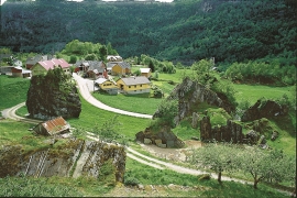
Botnen
Fyksesundet and Botnagrenda present a fine experience of the landscape and cultural history; a geographically isolated local settlement with extensive cultural contact with the outside world.

Fitjarøyane
If we study the group of islands south of Selbjørns Fjord from the air or on a sea map, we will notice that many of the islands are elongated and lie systematically in rows. The islands are divided by long sounds, for example Trollosen, Nuleia and Hjelmosen, which are oriented in a south-southeast to north-northwesterly direction.


Mundheim
At Mundheim there is a dangerous stretch of the highway. The mountainside has given way several times in this area. Typically, it happens in the spring, when the frost has loosened its grip.

Steinsdalsfossen
Øvsthusfossen, or Steinsdalsfossen waterfall, as it is called today, attracts tourists by the thousands, and always has done as long as there have been tourists in Norway, since the early 1800s.

