- Remove Maritime environments filter Maritime environments
- Remove Austrheim filter Austrheim
- Remove Nordhordland filter Nordhordland
- Remove Place filter Place
- Remove Vaksdal filter Vaksdal
- Remove Factories filter Factories
- Remove Farm sites filter Farm sites
- Remove Quarns and mills filter Quarns and mills
- Remove Radøy, frå 2020 del av nye Alver kommune. filter Radøy, frå 2020 del av nye Alver kommune.
- Remove Archaeological findings filter Archaeological findings
- Remove Wetland filter Wetland
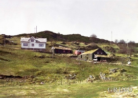
Øvre Tveiten
On an east-facing slope above Halllandsvatnet lies the farm hamlet of Øvre Tveiten, two kilometres north of Manger. The stone hayshed lies with its gable out into the sloping terrain, and the old dwelling house, a little long house, has solid stone walls on three sides. But inside the walls the hayshed and the living rooms are wooden buildings.


Toska
The peat bogs on Toska have been mined for peat since 1946, when the island got electricity. In this treeless coastal landscape, peat was the most important source of energy, and this took quite a toll on the bogs.


Skipshelleren
For vel 7000 år sidan var Straume ein av dei beste – om ikkje den beste – veideplassen i Hordaland. Steinalderfolket som busette seg ved Skipshelleren, skjøna truleg ikkje kor heldige dei var. Mellom dei opptil 2 meter tjukke dyngjene med stein og bein som arkeologar grov fram i 1931–32, fann dei reiskapar og avfall frå fangst og matstell. Frå dette materialet har arkeologane stava seg fram til livet ved straumen.

Purkebolsvatnet
Lake Purkebolsvatnet is perhaps western Norway's largest sleeping city - for birds. They come in the thousands, usually in later summer and autumn. The barn swallows alone number 10 000 - 12 000 at their most numerous.

Myking
Between Lake Kvalheimsvatnet and Lake Mykingsvatnet, north of Grindheim, we find one of the biggest continuous lowland bogs in Hordaland. It is 500-600 metres across and a whole 2 kilometres long. Locally, the bog is called "Havet" .


