- Remove Small landforms filter Small landforms
- Remove Maritime environments filter Maritime environments
- Remove People and Society filter People and Society
- Remove Defense filter Defense
- Remove Midthordland filter Midthordland
- Remove Churches, Cloisters, Christianity filter Churches, Cloisters, Christianity
- Remove Monastery filter Monastery
- Remove Museum filter Museum
- Remove Settlements, Villages, Towns filter Settlements, Villages, Towns
- Remove Lakes, rivers and river networks filter Lakes, rivers and river networks

Bryggen
In the 1300s Bergen was a trading centre of European dimension. The town is thought to have had around 7000 inhabitants and was the largest and most important in the country. In a European context it was an average size town. At this time the most tightly built town area was still mostly east of Vågen from Holmen in the north to Vågsbotn in the south. Already in medieval times, latest in the 1340s, this area was called Bryggen.
Damsgård
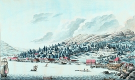
As a fairytale castle Damsgård Hovedgård lies on the slope rising up from the Puddefjord. The old connection between the farm and the sea, as we see it on Dreier’s prospectus from 1810, has been broken up by roads and encroachments in the building mass. But the main building itself is a central monument in Norwegian architecture from the 1700s – one of the finest representatives for the rococo period, with a magnificent and rich décor both in its interior and exterior.

Salhus
Salhus has been a connecting point for sea travellers far back in time. The name probably derives from the Old Norse word sáluhús, “house for travellers”. The name may indicate that this was a place for an inn even in the Middle Ages. The place is eminently situated in the route to and from Bergen. For travellers coming by boat from Sogn and Nordhordland, Salhus is the last stop before Bergen. Travellers from the communities in Voss also came this way earlier when they were going to Bergen
Ramsøy
“At thick of night a thundering knock on the door; the man in the house wakes up, jumps out and demands: Who cries? Yes, now you must out, the beacon shines on Høgenut. And in the same breath, every man knew that strife had hit the land.”

Landro
Landro has been the largest estate on Sotra, including 15 farms with reasonable conditions for agriculture. Their boathouses have had an excellent harbour in Landrovågen. Landro thus has been a good basis for the combination of agriculture and fishing.

Notaholmen
The fishnet shed at Notaholmen stands as a reminder of the days when people used to row out on the fjord to set their nets. On Notaholmen the nets were dried, repaired and tanned. And it was a great advantage to store them in a place inaccessible for rats and mice.

Golta- Long house
In the years between the wars a major registration of houses and house costumes, house construction methods, fireplaces and forms of housing clusters was started in West Norway – an ambitious mapping of everything that came under the name “Registration of Culture and Geography in West Norway”. One of the places of which material was gathered in 1938 was an old multi-room house at Golta; new and interesting material for the researchers from the Historical Museum, but well known within the local building tradition through several generations.

Tælavåg
Tælavåg has a significant place in the history of the German occupation in WWII. The small community by the sea, where for centuries people had made a living from farming and fishing in harmony with the natural resources, in 1942 became the victim of German reprisals without their equal in Norwegian war history. The collection of war histories in Tælavåg provides us with a close-up of the dramatic events.

Hjelmo
On the farm Hjelmo, furthest north in Øygarden, in the innermost part of a long bay, there is a fine boatshed collection with a church beside it. From times immemorial this has probably been the fish-shed location for these farm units and this was also the landing place for the churchgoers.


