- Remove Place filter Place
- Remove Metamorphic rocks filter Metamorphic rocks
- Remove Wetland filter Wetland

Granvinsvassdraget
After the ice age, Granvin Fjord reached all the way up under Skjervsfjossen waterfall. Just a thousand years later, as a result of the rising of the land after the ice melted, this whole inner part of the fjord freed itself of the sea and became Granvinsvatnet lake. In spite of this rise in elevation, this waterway is still navigable for fish: Sea trout have wandered into Granvinsvatnet in more recent times and evolved to become freshwater trout. And salmon and sea trout made the journey 13 kilometres up the Storelvi river.

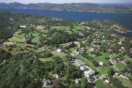
Ulvikapollen
When the lush beach area innermost in Ulvikapollen was protected, the bird life was instrumental to the decision. The plant diversity is just as impressive. In Hordaland sea meadows such as this are rare small in size - they are more common in coastal environments.
Ask- jordbær
Strawberry-growing on Askøy flourished in the beginning of the last century. When gardener Samson Eik took in the type "Seierherren" from Rosendal in 1909 for growing strawberries on Hop, it appeared that the soil and climate in this area was perfect for the mass production of strawberries.


Gullbotnen
A barren belt where almost nothing grows, runs through the forest on the east slope of Gullbotnen. But, along the west side of the main road there is a fertile zone that flourishes with several finicky plant types. The contrasts arise from the extreme variations in the nutrient content of the bedrock.


Golta- Gneiss
Over thousands of years, autumn storms and strong land-driving winds have cleaned the bare rocks of Golta. The waves can beat far in over land and make it dangerous to walk along the shoreline. When the storms have calmed, the results of their work comes into view.

Leirvågen
A marsh is a grassy meadow that is strongly influenced by salt from the sea. This type of nature is abundant in Denmark, among other places. The flatlands along the river that run out by Leirvågen, are the municipalities' largest marsh. At spring tide, these flatlands are flooded underwater for several hundred metres in over land.


