- Remove Quarns and mills filter Quarns and mills
- Remove Mineral resources filter Mineral resources
- Remove Tourism filter Tourism
- Remove Monastery filter Monastery

Bjørsvik
The industrial settlement Bjørsvik

Toska
The peat bogs on Toska have been mined for peat since 1946, when the island got electricity. In this treeless coastal landscape, peat was the most important source of energy, and this took quite a toll on the bogs.

Vågenes
On Vågenes, on one of the prominences out toward Eitrevågen, one finds garnets in anorthosite. The garnets are both older, and not least bigger, than average.
Lykling- gold
During the summer of 1979 a rock was found at Lykling in Bømlo that contained 450 grams of gold, and at the end of the 1980s a great many gold samples were laid out for sale. In the old mining area there are still gold miners hunting for the precious metal. But, the big adventure stories are a thing of the past.

Grønafjellet
Mountain plants with their beautiful, colourful flowers are common in high altitude areas in Norway. On the coast there are not so many of them. But, here and there one nonetheless finds mountain plants, and this makes some coastal mountainsides a little bit different. Perhaps the growth on these mountainsides gives us a little glimpse of a distant past?

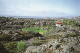
Godøysund
The old hostelry centres were strategically placed with good harbours and anchoring conditions where people travelled. GODØYSUND, or Gøysundet, as it was called, was in the middle of Tysnes Parish, with easy access from the sea, also for the local population. Gøysundet is amongst the oldest hostelries in Sunnhordland.


Rekvemylna
If you enter the farmyard at Rekve, some kilometres from Bulken, where the road departs to Giljarhus, you no longer meet “the miller”, Knut Hernes, in his old rural mill. But some years ago he would wish you welcome, friendly and hospitable, and show you around his mill, which had been his workplace for a generation. As light-footed as a youth he climbed in steep ladders high up into the waterfall, to let the water down on to the waterwheel.

Stalheim
Stalheim is situated between Stalheimsfossen and Sivlefossen, in a community with the farms Sivle and Brekke. The most likely explanation of the name is “the farm by Stadall”, from “standa” (stand), probably with background in the steep Stalheimskleivi. The farm has for a long time been divided into several units. At Stalheim there has been a transport exchange from the Middle Ages and the farm has been a postal farm since 1647.

