- Remove Quarns and mills filter Quarns and mills
- Remove Wetland filter Wetland
- Remove Farm sites filter Farm sites


Vinnesleira
Bays that are shallow far out into the sea, with fine sand and clay, are rare in Hordaland. Where they are found, the reason is usually that the edge of the glacier made smaller advances or stopovers when it calved back at the end of the last Ice Age. This is what happened at Vinnesleira.
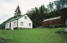
Øpstad
The post house at Øpstad stands out in the landscape. An ochre yellow house with a loft and a white-painted house in Swiss style with ochre edgings, bears witness to a well preserved house from the 1800s, nearest neighbour to the beautiful old vicarage. In the Øpstad hamlet there was a post office for more than a hundred years, until the 1970s. Today it is possible to walk the old post road across the mountain to Strandvik, as part of “Den Stavangerske Postvei” (The post road to Stavanger).

Hjølmo
In the steep hillside in Hjølmodalen, a small side valley from Øvre Eidfjord (Upper Eidfjord), which has been a key entrance to the Hardanger Plateau, the hamlet of old farmhouses still lie clustered together. The yard is empty today, some of the houses are used in the summer, but the grass grows round all the corners.

Kjeåsen
High up above the fjord, at a height of 600m lie the two holdings at Kjeåsen. Today you can drive there by car, through a new tunnel that the power engineers in Sima have drilled. Until 1974 the only road went up the steep hillside, along iron bolted ladders across dizzying rocks – a road for the strong at heart.

Langavassmyrane
The Ruff lek on Langvassmyrane is the only known phenomenon of its kind on Hardangervidda. Every year it attracts hens from the whole plateau. The marsh is also the richest wetland in the county. This green oasis is located in a rocky moraine landscape a few hours walking distance south of Dyranut.

Måbø
Måbø is the uppermost farm in Måbødalen. This narrow and steep mountain valley has been one of the routes from the fjord communities up to the mountain plateau from times immemorial. We are not certain of the meaning of the name Måbø. Perhaps it has its origin in an Old Norse male name Mávi, from the name for seagull, már. The last syllable “bø” means farm. Today Måbø gives us a compact close-up of the subsistence economy: the small farm with the clearance piles, stone walls and a lane that guided the animals into the yard, at the foot of the great mountain expanse.

Granvinsvassdraget
After the ice age, Granvin Fjord reached all the way up under Skjervsfjossen waterfall. Just a thousand years later, as a result of the rising of the land after the ice melted, this whole inner part of the fjord freed itself of the sea and became Granvinsvatnet lake. In spite of this rise in elevation, this waterway is still navigable for fish: Sea trout have wandered into Granvinsvatnet in more recent times and evolved to become freshwater trout. And salmon and sea trout made the journey 13 kilometres up the Storelvi river.


