- Remove Smallholdings filter Smallholdings
- Remove Large landforms filter Large landforms
- Remove Railroad filter Railroad
- Remove Sedimentary rocks filter Sedimentary rocks

Skjervet- river theft
At the end of the last ice age the ice flowed out of Hardanger fjord in such a fury that it forced the meltwater from Voss to run back uphill toward Granvin. The glacier from Raundalen down the windy valley along the Vosso to Bolstadøyri went too slow to make the turn.

Bergensbanen
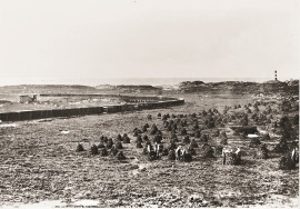
Already at the beginning of the 1870s demands were made that there had to be a railway connection between Bergen and East Norway. The first section between Bergen and Voss was finished in 1883. The route alternatives further on were many: Lærdal-Valdres, Aurland-Geiteryggen, Raundalen-Finse and Ulvik-Finse. Following a long dispute, an agreement was finally reached that the middle route alternative, Raundalen- Myrdal- Finse, was the best alternative. In 1894 the government passed a resolution that the Bergen railway should be built, but only the section Voss-Taugevatn. This was a political gamble in order to make the rest of the country participate in the plans. In 1898 it was approved that the railway be continued eastwards from Taugevatn to Oslo. This high mountain project was one of the most challenging railway projects in Europe. The Bergen railway was to be built across a mountain plateau without roads.

Bergensbanen- snow measurements
Opponents of the Bergen Railway used the snow argument for all it was worth. During the debate in Parliament before the decision about the route was reached in 1894, fears of snowfalls of over 20 metres were presented.

Trail toward Kyrkjedøri
Roughly 550 million years ago, what is now Finse lay at the bottom of the sea - the remains of mud and clay that were deposited in this sea have ended up on the roofs of Norway. Also the thrust sheet from the continental collision has found its way to Finse, after a several hundred kilometre-long, trek through the mountains, that took several tens of millions of years to complete.


Vatlestraumen
There are coal bits hidden in the sand under Vatlestraumen. These remains from a geological layer from the Jurassic Period were discovered when the undersea Bjorøy Tunnel was built in 1994. Oil- and gas reservoirs in the Troll Field in the sea west of Hordaland are from the same time. It is, nonetheless, quite surprising to find bedrock from dinosaur time inside of the outer islands of western Norway. On the Scandinavian mainland north of Denmark, there are only a very few places where one f inds rock from this time in earth history.

Holmengrå
Holmengrå is the only place in Hordaland where we find traces of the abrasion that is supposed to have transformed Western Norway from a Himalaya-like high mountain landscape during the earth's Paleozoic Era, to a flat lowlands terrain during the Mezosoic Era. Just 400 million years ago, large and small stones plummeted down from the high mountains. Some of these stones became incorporated into the conglomerate bedrock on Holmengrå.
Stormark
Both the climate and people have been decisive in shaping the bog landscape on Fedje - a landscape that has been evolving over several thousands of years. The peat got built up layer for layer and provided income and fuel for the people of Fedje.

Dyrdal
If you journey along Austfjorden, you at the same time turn the pages of time back through Ice Age history. The landforms show how the landscape has developed gradually as the glaciers have grown - and melted again - in several episodes: from small cirques, we see innermost at Dyrdal, to larger fjords, like at Mas fjord further out.

Eldsfjellet
The eclogites in western Norway were formed when Precambrian basement rocks were squeezed and pressed down under great pressure deep under the Caledonian mountain chain. The process may well have triggered some of the deepest earthquakes the world has ever known. The clearest traces of this drama are found in and around Mt. Eldsfjellet, in peaceful Meland.

