- Remove Smallholdings filter Smallholdings
- Remove Igneous rocks filter Igneous rocks
- Remove Defense filter Defense
- Remove Avalanches and rock falls filter Avalanches and rock falls

Urangsvågen-Rubbestadneset
In 1868 the first stone workers came to Rubbestadneset to take out the granite for the Skoltegrunns Pier, predecessor of the Skoltegrunns wharf in Bergen. Later granite was also taken out from the area, around Innværs Fjord and UransvågenN. The activity probably peaked around 1900, with over 40 men at work. 15 years later, it was finished.

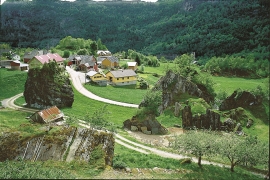
Fitjarøyane
If we study the group of islands south of Selbjørns Fjord from the air or on a sea map, we will notice that many of the islands are elongated and lie systematically in rows. The islands are divided by long sounds, for example Trollosen, Nuleia and Hjelmosen, which are oriented in a south-southeast to north-northwesterly direction.


Kattnakken–Stovegolvet
The highest mountainous area on Stord, including Kattnakken, Midtfjellet and Stovegolvet, has more in common with the mountainous terrain on the mainland than in the low coastal landscape of Sunnhordland. The volcanic bedrock together with the erosive powers of nature has resulted in a unique plateau landscape.

Espevik
220 million years ago, glowing hot molten rock masses intruded into fractures in the earth's crust in the outer parts of Hordaland. Some of these are believed to have reached the surface and formed lava flows, which since have been eroded away by wind and weather. But, most of these flows solidified into diabase sills before they got to the surface.


Nedrevåge
Vågsbygdo was severely hit by landslides and rock falls in the decades around 1700, in addition, the rivers transported masses of loose sediment, both large stones and gravel. A lot of what slid down from the Vågsliene (slopes at Våg) collected in Neravåge. It was so bad that the damage “never again can be remedied or restored”, it was said in 1670.

Teigdalen
It is not surprising that there are several folk tales connected to the large and unusual scree deposit that is found at Langeland, uppermost in Teigdalen. It is said that folk have been taken into the mountains by these stone blocks and have come back and told about how the wood nymphs live. It is also said that packs of thieves hid here in the old days, both themselves and the treasures they had stolen.

Mundheim
At Mundheim there is a dangerous stretch of the highway. The mountainside has given way several times in this area. Typically, it happens in the spring, when the frost has loosened its grip.

