- Remove Smallholdings filter Smallholdings
- Remove Igneous rocks filter Igneous rocks
- Remove Defense filter Defense
- Remove Lakes, rivers and river networks filter Lakes, rivers and river networks


Fitjarøyane
If we study the group of islands south of Selbjørns Fjord from the air or on a sea map, we will notice that many of the islands are elongated and lie systematically in rows. The islands are divided by long sounds, for example Trollosen, Nuleia and Hjelmosen, which are oriented in a south-southeast to north-northwesterly direction.

Kattnakken–Stovegolvet
The highest mountainous area on Stord, including Kattnakken, Midtfjellet and Stovegolvet, has more in common with the mountainous terrain on the mainland than in the low coastal landscape of Sunnhordland. The volcanic bedrock together with the erosive powers of nature has resulted in a unique plateau landscape.

Ådlandsvatnet
Plants that grow in and beside water have to be prepared for marked and rapid changes in their living conditions. They must be able to tolerate living under water without drowning, and getting totally dried out without whithering. Many swamp plants are well adapted to these kinds of changes.

Espevik
220 million years ago, glowing hot molten rock masses intruded into fractures in the earth's crust in the outer parts of Hordaland. Some of these are believed to have reached the surface and formed lava flows, which since have been eroded away by wind and weather. But, most of these flows solidified into diabase sills before they got to the surface.


The Vosso river network
The Vosso is Hordaland's main artery, she has never run more richly than in our times, and no other river in western Norway carries so much water. The increase in the amount of water comes mainly from hydropower development, due to the transfer of water from other water systems. Climate change can also be a reason that the Vosso carries more water than before.
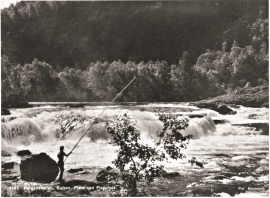
Vosso
There is probably no bigger salmon to be found in the whole wide world than in Vosso. The average size varies from season to season of course, but for many years this fish has had an average weight of over 10 kilograms. Thumping big ones of 30 kg. have been fished from the river, but one must go back to the 1940s for the last salmon of this size last that was caught.

