- Remove Boat- and shipyards filter Boat- and shipyards
- Remove Large landforms filter Large landforms
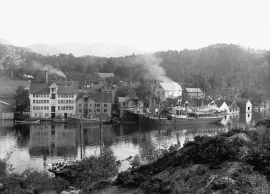
Sunde
In 1852 Haktor Thorsen erected two large warehouses on one of his farms in Sunde and started trading and salting herring. This was the start of an industrial adventure that made Sunde into one of the first industrial communities in Kvinnherad.

Tokagjelet
There is a sharp transition between the wide valley at Kvamskogen and the narrow Tokagjelet. The transition is no less dramatic when we come out of the crooked tunnels far down in the canyon, and the open Steinsdalen valley spreads out before us. The canyon both separates and joins together different epochs in western Norway's history.

Ulvanosa
Some mountains have rounded shapes, while others have steep slopes and sharp edges. Ulvanosa (1246 mos.) has both. The forms reflect the type of bedrock below, and the forces that were in effect when they were formed.

Verftet
Today the name “Verftet” is linked to both a district and conglomeration of buildings lying protected by Fredriksberg castle. The original shipyard was founded in the 1780s by Georg Brunchorst and Georg Vedeler. It was called Gerogenes Verft (the shipyards of the Georgs), and here ships were both built and repaired in the years after 1786.


Åsane
Most associate Åsane with ridges, naturally enough (the Norwegian word for "ridge" is "Ås"). A lesser noticed trait in the landscape are the unusual flat areas that lie between the ridges. The Dalselva River, which was channeled at the end of the 1950s, runs down only 2.5 metres from Lake Langavatnet by Vågsbotn to Flatevad, where it goes over into rapids by Fossekleiva. The layers of gneiss stand nearly vertically, and the mountain surface is so even that one might think it had been planed with a planer.
Pages
- « first
- ‹ previous
- 1
- 2
- 3
- 4

