- Remove Smallholdings filter Smallholdings
- Remove Large landforms filter Large landforms
- Remove Archaeological findings filter Archaeological findings
- Remove Fisheries filter Fisheries


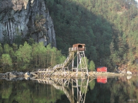
Skipshelleren
For vel 7000 år sidan var Straume ein av dei beste – om ikkje den beste – veideplassen i Hordaland. Steinalderfolket som busette seg ved Skipshelleren, skjøna truleg ikkje kor heldige dei var. Mellom dei opptil 2 meter tjukke dyngjene med stein og bein som arkeologar grov fram i 1931–32, fann dei reiskapar og avfall frå fangst og matstell. Frå dette materialet har arkeologane stava seg fram til livet ved straumen.
Straume- Salmon
From times immemorial salmon and trout have been caught with various tools in the fjord and the streams here. Finds in the Stone Age settlements at Skipshelleren indicate that salmon was probably caught by angling. Nets, fish pots and traps have been used in the rivers right up to our times. In the fjords the use of nets was developed into a salmon seine around 1500, and later into what today is known as fixed seine.


Espevær- the Trading Post
In the sea west of Bømlo lies Espevær, half an hour’s rowing trip across the sound from Vespestadvågen. This is a well-run and well-maintained local community, established on the back of the rich herring fisheries in the 1850s. It is fishermen, skippers and the tradesmen who have made their mark on the culture in Espevær, with their contacts to the south towards Haugesund and across the North Sea to the British Isles.


Siggjo
Siggjo is a cone-shaped, volcano-like mountaintop in the part of Hordaland where one finds the best preserved volcanic rocks. The rock types originate from one or several volcanoes that spewed out glowing lava and ash. But, the shape of the mountain, as it appears today, formed later and by completely different forces.


Fitjar- the King's farm
In front of Fitjar Church there is a memorial stone, sculpted by Anne Grimdalen and erected in 1961, for the thousand-year memorial of one of the most dramatic events in Norway’s history, the Battle of Fitjar. This was the place where Norway’s king, Håkon the Good, suffered his fatal injury in the fight with Eirik’s sons, probably in the year 961.

Fitjarøyane
If we study the group of islands south of Selbjørns Fjord from the air or on a sea map, we will notice that many of the islands are elongated and lie systematically in rows. The islands are divided by long sounds, for example Trollosen, Nuleia and Hjelmosen, which are oriented in a south-southeast to north-northwesterly direction.

