- Remove Small landforms filter Small landforms
- Remove Thrust sheets filter Thrust sheets
- Remove Coniferous forests filter Coniferous forests
- Remove Hydro power filter Hydro power


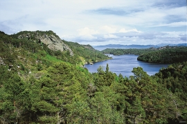
Hisøya
"I am going to prove to you that I am right". That is what the idealist and county doctor Christian Heitmann is supposed to have said in the early 1890s. He sat together with the parish priest, Kullmann, at Heitmann's home in Stord and discussed whether the islands in western Norway could have been forested or not. The priest thought that the area was too barren and weather-beaten for forest to have been able to grow so far out in the sea. But, Heitmann was sure he was right. He challenged the scepticism and set off to work.

Siggjo
Siggjo is a cone-shaped, volcano-like mountaintop in the part of Hordaland where one finds the best preserved volcanic rocks. The rock types originate from one or several volcanoes that spewed out glowing lava and ash. But, the shape of the mountain, as it appears today, formed later and by completely different forces.
Skogafjellet
You have to travel to Scotland in order to find pine forests similar to those at Bømlo. The nearness to the sea has contributed in different ways to shaping one of the westernmost pine forests in Norway.

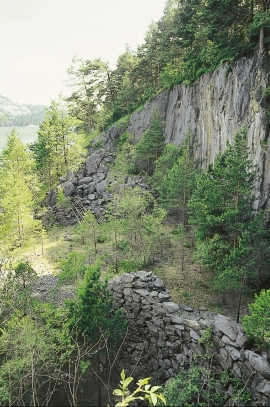
Urangsvågen-Rubbestadneset
In 1868 the first stone workers came to Rubbestadneset to take out the granite for the Skoltegrunns Pier, predecessor of the Skoltegrunns wharf in Bergen. Later granite was also taken out from the area, around Innværs Fjord and UransvågenN. The activity probably peaked around 1900, with over 40 men at work. 15 years later, it was finished.


Storsøya Island
On Storsøya Island, English ivy grows nearly everywhere. It creeps along the ground and climbs all the way to the top of the tree trunks. Together with holly, the trees of juniper, yew and an unusual pine forest keep the island green the whole year 'round.

Hopsfjellet
On June 2nd, 1992, a big forest fire broke out in Sveio. The fire started southeast of Hopsfjellet. In a strong wind the flames spread quickly northward. Houses on the other side of the highway were threatened, but escaped unscathed. The burned area, which is easily visible about a 5 minute's drive south from the tunnel at the triple- junction, was made into a nature reserve in 1998. The intention was to ensure that the re-establishment of plant- and animal life would take place without disturbance.


