- Remove Busetnad, bygd, by filter Busetnad, bygd, by
- Remove Weather and climate filter Weather and climate
- Remove Landscape filter Landscape
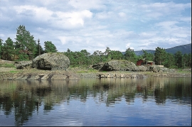
Storavatnet- shoreline
The regulation of Lake Storavatnet has created a rare geological phenomenon: When Herlandsfossen power station taps the reservoir during the spring and summer, the old shoreline of hard bedrock comes into view.

Toska
The peat bogs on Toska have been mined for peat since 1946, when the island got electricity. In this treeless coastal landscape, peat was the most important source of energy, and this took quite a toll on the bogs.

Eksingedalen- landscape
Eksingedalen alternates between wide, flat flood plains with good farmland, and narrow passages with waterfalls where the roads cling to the mountainsides. The alternations in the landscape are a result of the sculpturing work by glaciers over several ice ages, and the deposition of the glacial river deposits when the last glacier finally melted back.


The village of Etne
Much of the sand and gravel that the town of Etne is built on was laid down at the end of the Ice Age and is evidence of melting glaciers and roaring meltwater rivers. The uncompacted material in the big terraces leave their unmistakeable mark on the wide elongated valleys.

Etnedeltaet
During the latter half of the 1900s the big natural river deltas on Westland disappeared. Until the 1980s there was still a small, but significant remnant of the original river delta from the Etneelva river, but today most of this, too, is industrial land.


Fitjarøyane
If we study the group of islands south of Selbjørns Fjord from the air or on a sea map, we will notice that many of the islands are elongated and lie systematically in rows. The islands are divided by long sounds, for example Trollosen, Nuleia and Hjelmosen, which are oriented in a south-southeast to north-northwesterly direction.


